CINDE
Convective Initiation Downburst Experiment
The Convection Initiation and Downburst Experiment (CINDE) was conducted along the front range of the Rocky Mountains in the Denver, Colorado, area from 22 June to 7 August 1987. It was designed to further the understanding of the kinematic and thermodynamic structure of the boundary layer, emphasizing those processes that influence the development of convective storms, including terrain effects, and to investigate the forcing and initiation of intense downdrafts known as microbursts. The location was chosen to encompass a topographically induced feature known as the Denver convergence zone, and to collocate as much as possible with three other experiments. These experiments were the Terminal Doppler Weather Radar (TDWR) operational test, the Denver Advanced Weather Information Processing System (AWIPS)-90 Risk Reduction and Requirement Evaluation, and a precipitation and cloud-physics study conducted by Colorado State University (CSU) using the NCAR (National Center for Atmospheric Research) multiparameter CP-2 radar. A high degree of cooperation occurred between the projects including the sharing of facilities, data, and scientific personnel. Twenty-nine scientists from 6 institutions [CSU, NCAR, National Oceanic and Atmospheric Administration (NOAA), University of California at Los Angeles (UCLA), University of North Dakota (UND), and University of Wyoming (UWYO)] participated in CINDE.
SCIENTIFIC OBJECTIVES
The scientific objectives related to the convective storms and downbursts and their development and evolution were a logical follow-on to research conducted during the 1982 Joint Airport Weather Studies (JAWS) and 1986 Microburst and Severe Thunderstorm (MIST) programs. Specific objectives of CINDE were:
a. Convection Initiation
- Gain an improved understanding of the dynamics and thermodynamics of the planetary boundary layer in relation to convergence lines that develop as a result of thunderstorm outflows, synoptic fronts, gravity waves, surface moisture discontinuities, topography, and other factors.
- Document the development of clouds and convective storms that occur along these convergence lines, and identify factors controlling preferred locations, periods, and scales of convective development.
- Determine the time and space changes in the larger-scale environment with particular consideration for topographic influences affecting convergence line formation. This will be accomplished by measuring the evolving vertical profiles of moisture, temperature, and winds throughout the troposphere prior to convective development.
b. Downbursts
- Investigate the fine-scale dynamics and thermodynamics of the downdraft-initiation processes. A principal goal is to determine what dynamical events are responsible for producing a microburst in one storm and not in another nearby storm.
- Identify radar features that may be useful for anticipating those storms that will produce downbursts vs. those that will not.
- Examine the fine-scale vertical and horizontal structure of downburst outflows.
- Determine the kinematic and thermodynamic structure of downdrafts resulting from "virga-type" microbursts that originate from cloud remnants of mountain convection. These clouds often appear to be stratiform; an important question is whether the downburst-producing virga originates from stratiform or convective processes.
c. Tornadoes
While the study of tornadoes was not a planned objective, the occurrence of at least 25 tornadoes within the heavily instrumented network provided a unique opportunity. These tornadoes, which were typical of the region, were significantly weaker than those traditionally studied in the Midwest. They were associated with non-rotating storms in their rapid development stage, rather than the more often studied tornado that is associated with supercell storms. High-resolution dual-Doppler radar data were available for at least one case, providing a unique opportunity to study vorticity production. Also, because of the great number of tornadoes of apparently similar type observed, it may be possible to provide a comprehensive description of their characteristics and formation processes.
OBSERVATIONS
a. Surface Meso-networks (i.e. Mesonets)
- NCAR PAM Network - 46 Portable Automated Mesonet (PAM) II weather stations were deployed with Forty-one stations comprising the primary grid, with a typical station spacing of about 10 km. The purpose of this network was to provide time and space continuity of surface mesoscale features moving through the dual-Doppler region. The remaining five PAM II stations were deployed in areas surrounding this network. The stations to the south were located to observe the origins of terrain-induced mesoscale features; the two near the foothills west of Denver were placed to observe thermal and wind features resulting from mountain convection. The PAM II stations provided 1-min averages of standard meteorological variables.
- PROFS and FLOWS Networks – The NOAA Program for Regional Observing and Forecasting Services (PROFS) and the Federal Aviation Administration (FAA)-Lincoln Laboratory (LL) Operational Weather Studies (FLOWS) mesonet stations were located in and around the PAM II network and provided additional information on the structure of the mesoscale meteorological fields over the region. The PROFS automated mesonet contained 22 stations recording 5-min averages of standard meteorological variables and 11 of the stations were located within the CINDE network. The FLOWS mesonet consisted of 30 stations contained in a 15 km x 10 km array centered on Stapleton Airport. The stations operated continuously and recorded 1-min averages of standard meteorological variables.
b. Soundings
- CLASS - A fixed network of upper-air sounding stations consisted of 5 NCAR Cross-chain LORAN (Long-Range Aid to Navigation) Atmospheric Sounding System (CLASS) stations located at sites near Hudson, Byers, Elizabeth, Golden, and Stapleton Airport. The CLASS soundings provided real-time vertical profiles of thermodynamic and wind variables at 10-sec intervals (vertical resolution ~ 50-m or 5-mb).
- Mobile - Three mobile sounding van systems were used to supplement the soundings made from the fixed CLASS sites. These systems utilized the Atmospheric Instrumentation Research (AIR) Automatic Data Acquisition System (ADAS) sounding equipment providing thermodynamic profile data at 5-sec intervals. Winds aloft were obtained by tracking the balloon visually using an optical theodolite.
c. Radars
Three radars were dedicated to CINDE. They were the NOAA-C and NOAA-D, X-band Doppler radars and the NCAR CP-3, C-band Doppler radar (located at the Denver Stapleton International Airport). The NOAA radars were separated by 15.9 km, allowing for high resolution dual-Doppler measurements. While the two NOAA radars were the same in most respects, NOAA-C had additional dual-circular polarization capability. A Cessna 182 single engine aircraft was employed to dispense chaff since the NOAA radars had only a limited clear air detection capability. The NCAR CP-2 Doppler radar was operated from 10 July to 10 August in support of a research program of CSU. Prior to 10 July, CP-2 was operated for PROFS in connection with real-time nowcasting experiments being conducted by PROFS and the NOAA National Weather Service (NWS). In addition, two other radars, the FL-2 S-band Doppler from Lincoln Laboratory and the UND C-band Doppler radar, were located within the CINDE network. These radars collected data primarily for the TDWR program.
d. Research Aircraft
The airborne research activities were planned around the capabilities of two Beechcraft King Air aircraft, one operated by the Research Aviation Facility of NCAR (Tail N312D), and the other by the UWYO (Tail N2UW). A Cessna Citation (Tail N77ND) flown by the UND Center for the Aerospace Sciences under contract to FAA in cooperation with Lincoln Laboratories was a planned component in the TDWR research program and was available in a cooperative role. The King Air aircraft were available from 22 June through 28 July. The UND Citation was available to CINDE on an occasional basis from 7 July through 7 August. Research flights were primarily within the region covered by the dense PAM II surface mesonet. Flight levels ranged from minimum safe altitude to as high as 25,000 ft (-7.0 km). All three aircraft had a variety of sensors for making air motion and thermodynamic measurements. Cloud-physics instrumentation was also available for downburst studies. All three aircraft had a sophisticated pointer system allowing for accurate flying of complex flight patterns and tracking of individual air parcels.
e. Profilers
A pre-existing network of wind profilers operated by NOAA was present in the vicinity. One of these profilers was located within the CINDE network at the NWS Denver office. A second was located just north of the CINDE network at Platteville. The 50-MHz profiler at Platteville generated an average wind profile once per hour from about 1.7 km to 18 km above ground level (AGL). The 915-MHz profiler at Denver obtained an average profile every 12 min from about 0.3.to 5.5 km AGL.
NETWORK MAP
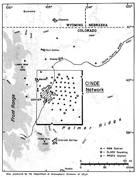 |
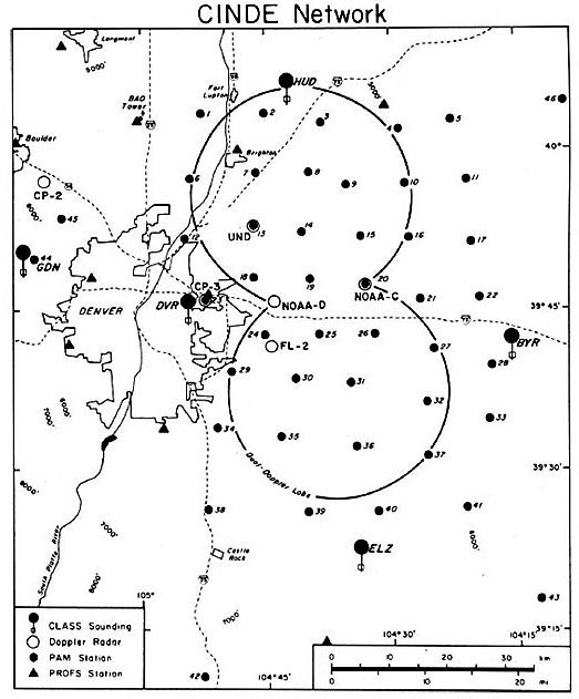 |
DATA
A total of 6 Doppler radars, 98 mesonet stations, 3 research aircraft, 8 sounding systems and numerous photographic facilities were deployed within an 85 km x 85 km area. A comprehensive data set was obtained including measurements of convergence lines (35 days), downbursts (22 days), and tornadoes (11 days).
| Aircraft | NCAR King Air; UWYO King Air; UND Citation; Boulder Flying Service Cessna 182 |
|---|---|
| Photography | NOAA and NCAR Ground-based 16-mm movies (3); NCAR super 8-mm (9); NCAR, NOAA, UCLA 35-mm still (8); NCAR, UWYO, UND Airborne 35-mm still and video (3); NOAA radar (2); PROFS Chase Team videos (3) |
| Profilers | NOAA/WPL 50 MHz (3); NOAA/WPL 915 MHz (1) |
| Radar | NCAR CP-3 C-band Doppler; NCAR CP-2 S/X-band Doppler; UND C-band Doppler; NOAA X-band Doppler (NOAA-C and NOAA-D); LL FLOWS S-band Doppler |
| Satellite | GOES-6 Vis and IR imagery; VAS |
| Surface | NCAR PAM-II (46); NOAA PROFS (22); LL FLOWS (30); |
| Surface | Routine Surface Synoptic Observations |
| Upper Air | NCAR CLASS fixed sites (5); AIR Mobile vans (3); NWS Denver MicroART fixed site |
| Upper Air | Routine NWS Soundings (00 and 12 UTC) in the Region |
PROJECT OPERATIONS
All experiment coordination was directed from a transportable operations center termed MOCCA (Mobile Operations Center for Communication and Analysis) that was developed at NCAR for use in CINDE. It was based on concepts used previously in the 1980 Cooperative Convective Precipitation Experiment (CCOPE) with important additional capabilities related to real-time analysis and nowcasting. MOCCA was located at Denver’s Stapleton Airport along with the CP-3 radar and the PAM-base trailer. It housed five communication consoles, six CP-3 radar displays, three PAM II real-time wind displays, a PAM II workstation and a synoptic and mesoscale workstation called The STORM Education and Research System (SERS). Eight primary work positions were housed in the facility including the operations director, radar analyst, radar scan optimizer, aircraft coordinator, sounding coordinator, experiment forecaster, nowcaster, and data analyst. The high quality, real-time radar displays provided two images, each with separate magnification and center with the capability of toggling between reflectivity and Doppler velocity. Real-time tracking of aircraft was performed through a link to the FAA Air Route Traffic Control Center and overlaid on the radar display. Flexible ground-to-air and ground-to-ground radio communication, and voice intercoms between the operations center and the field were provided.
Research operations were conducted daily. A planning meeting was held between 1000 and 1100 MDT (Mountain Daylight Time) at the operation center. The operations center staff and representatives of major research systems participated. A debriefing of the previous day's activities was conducted as part of the morning meeting. An operations director implemented the daily research plans with the assistance of the forecasters and system coordinators. Operations normally occurred between 1200 and 2000 MDT. There were provisions for early operations (0800-1100 MDT) in anticipation of the Denver Convergence Zone or other mesoscale environment studies. The Scientific Steering Committee had the responsibility of ensuring that the research objectives and goals, as specified in the experimental design, were adequately addressed during the course of the project. The committee met periodically throughout the experiment to review progress in the attainment of research goals and to consider shifts in research priorities based on results obtained to date.
Further information and details on CINDE can be found at: CINDE_Overview.pdf