CASP-I
Canadian Atlantic Storms Program
The first Canadian Atlantic Storms Program (CASP-I) field project was a cooperative joint oceanographic and meteorological mesoscale research program to examine the mesoscale structure and dynamics of winter storms and the associated oceanic response on Canada's east coast. It was conducted from 15
January to 15 March 1986 over the Atlantic Canadian Maritimes in conjunction with the U.S. Genesis of Atlantic Lows Experiment (GALE) conducted simultaneously on the U.S. east coast. Coordination between CASP-I and GALE was at the scientific, management, and steering committee levels, in many cases sampling the same storms as they modified and moved up the Atlantic coast.
CASP-I represented the first major Canadian effort designed specifically to improve the prediction of storm and mesoscale features. Because of the pioneering nature of the project, a number of coordinated studies were conducted in order to characterize the basic nature of the storms and an
increased understanding of the interaction of the storms with surface features such as coastlines and sea ice. Conceptual models of the storms have been formulated, the nature of cyclogenesis and the structure of frontal surfaces have been investigated, and precipitation regions and precipitation type
transitions have been studied. Numerical weather simulations have been used to better understand critical parameters affecting storm behavior and improvements in instrumentation have been made.
CASP-I also directly addressed at least five (5) of the recommendations related to environmental data, analysis and forecasts made by the Royal Commission on the Ocean Ranger Disaster (a semi-submersible mobile offshore drilling unit that sank in Canadian waters on the Grand Banks of Newfoundland on 15 February 1982). These recommendations included: (1) forecast improvement; (2) expanded observations and climatologies; (3) wind, waves, and currents; (4) measuring equipment; and (5) icing forecasts.
Resources for CASP-I “core” programs were provided by the Panel on Energy Research and Development (PERD) of the Department of Energy, Mines, and Resources (EMR). Participation in CASP included investigators at the Bedford Institute of Oceanography (BIO) of the Government of Canada Department of Fisheries and Oceans, the Atmospheric Environment Service (AES) of Environment Canada, several Canadian universities, the offshore petroleum industry, and the Department of National Defense (DND).
Scientific Objectives:
The primary goal of CASP-I was to begin the process of understanding and eventually better predicting the mesoscale structure of East Coast storms as well as the storms themselves. The mesoscale meteorology of these destructive storms was not well understood and presented great challenges to the
meteorological forecaster. Likewise, the oceanic response was poorly documented and required a more complete and quantitative understanding. The primary joint meteorological-oceanographic objectives of CASP-I were: (1) to further scientific interactions among meteorologists and oceanographers in the AES, Ocean Science and Surveys (OSS), Universities, and private industry; and (2) to improve the linkages between ocean and numerical weather prediction models on all scales. Specifically,
The objectives of the meteorological component of CASP-I were:
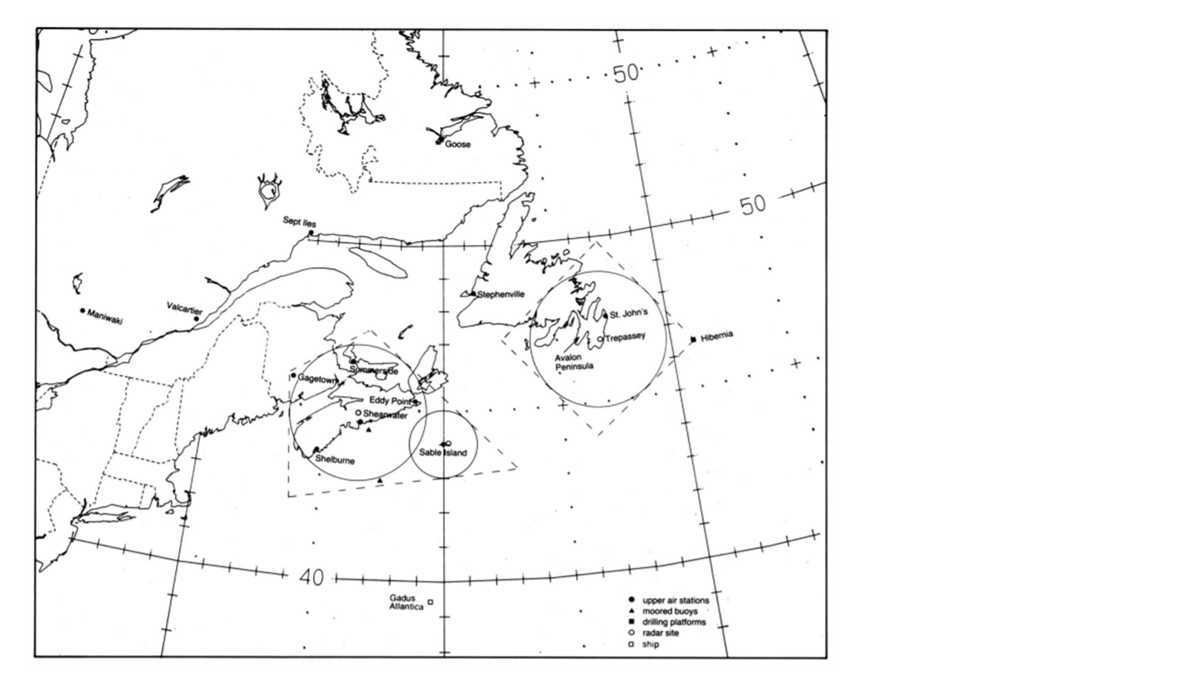
a) To describe the airflow, moisture, and precipitation fields of east coast winter storms, with special emphasis on mesoscale phenomena in the Nova Scotia/Sable Island and the Avalon Peninsula/Hibernia regions.
b) To improve the prediction of the mesoscale features of east coast winter storms as well as the storms themselves.
c) To improve the prediction of the oceanic response to mesoscale features.
d) To improve instrument capabilities and networks during the project for observing, characterizing, and predicting mesoscale and storm phenomena.
The objectives of the oceanographic component of CASP-I were:
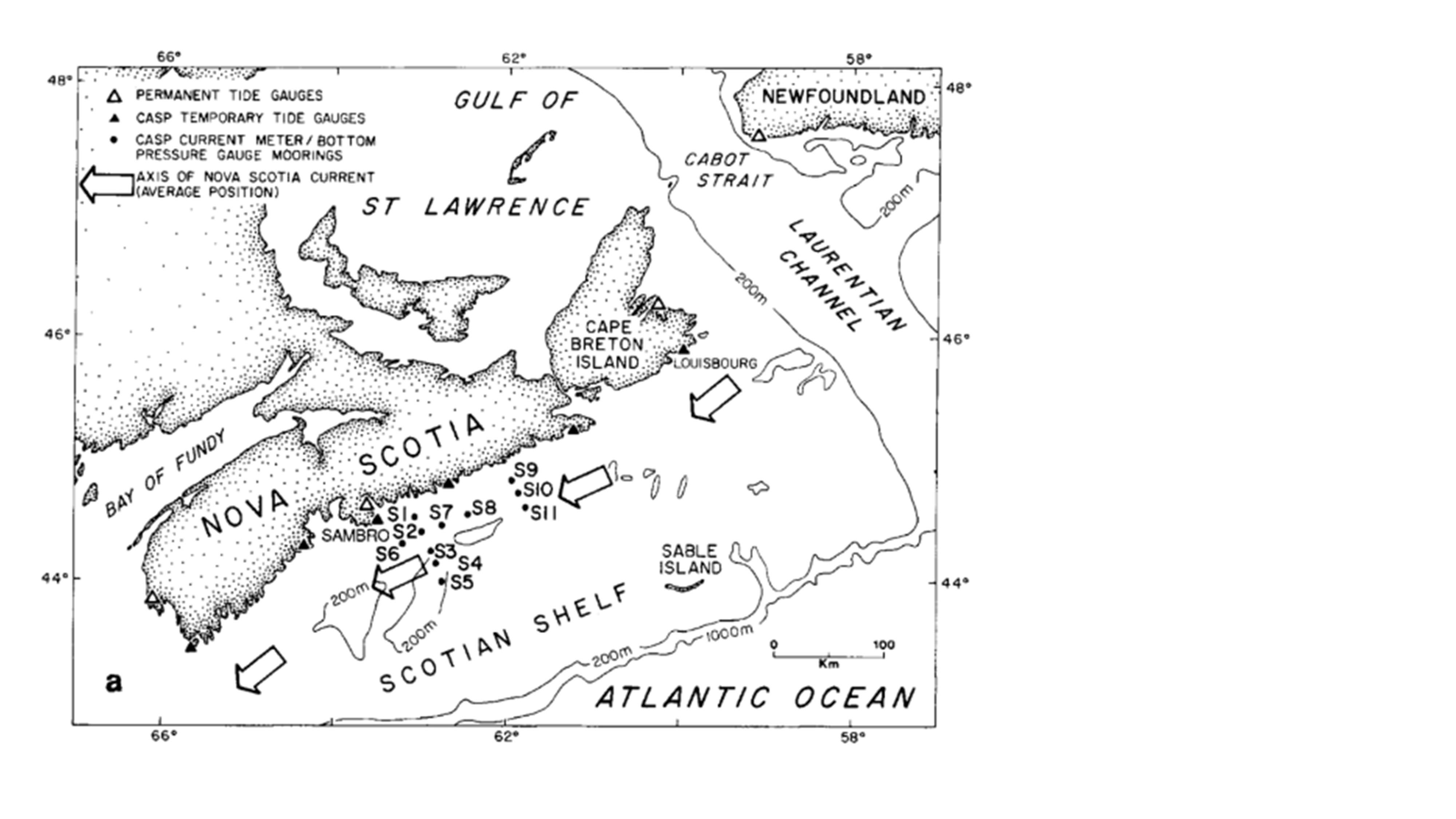
a) To observe the response of ocean currents, sea levels, bottom pressure, surface waves, and the density field on the Scotian Shelf of forcing by east coast winter storms.
b) To use the observations to validate analytical and numerical models of coastal ocean hydrodynamics.
c) To improve methods of forecasting shallow water surface waves by testing predictive models against wave observations.
d) To evaluate the instruments, mooring designs, data acquisition and processing systems, and project management methods used in the oceanographic component of CASP-I, and to initiate improvements therein for the benefit of future oceanographic field programs.
Project Operations and Observations:
 |
 |
 |
 |
Enhanced rawinsondes were released into the storms from a number of operational and portable sites, radar coverage was expanded at the indicated locations, surface mesonets (seventeen 10-m anemometer masts in a triangular array) were operated on Nova Scotia and Sable Island, and a multi-channel radiometer and special precipitation measurements were made at Shearwater, Nova Scotia. In addition, two instrumented aircraft (Twin Otter and DC-3) penetrated a number of storm features.
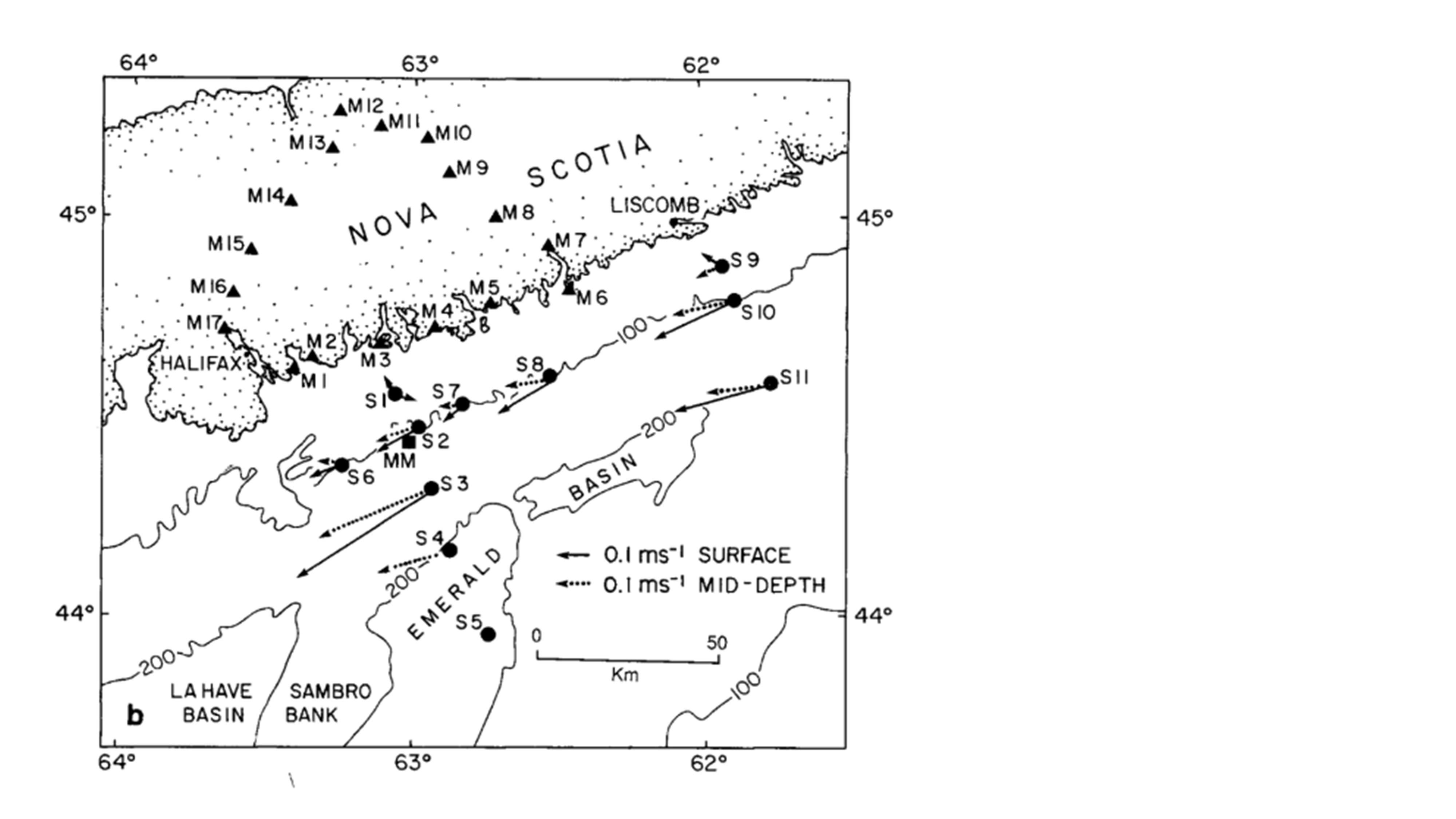
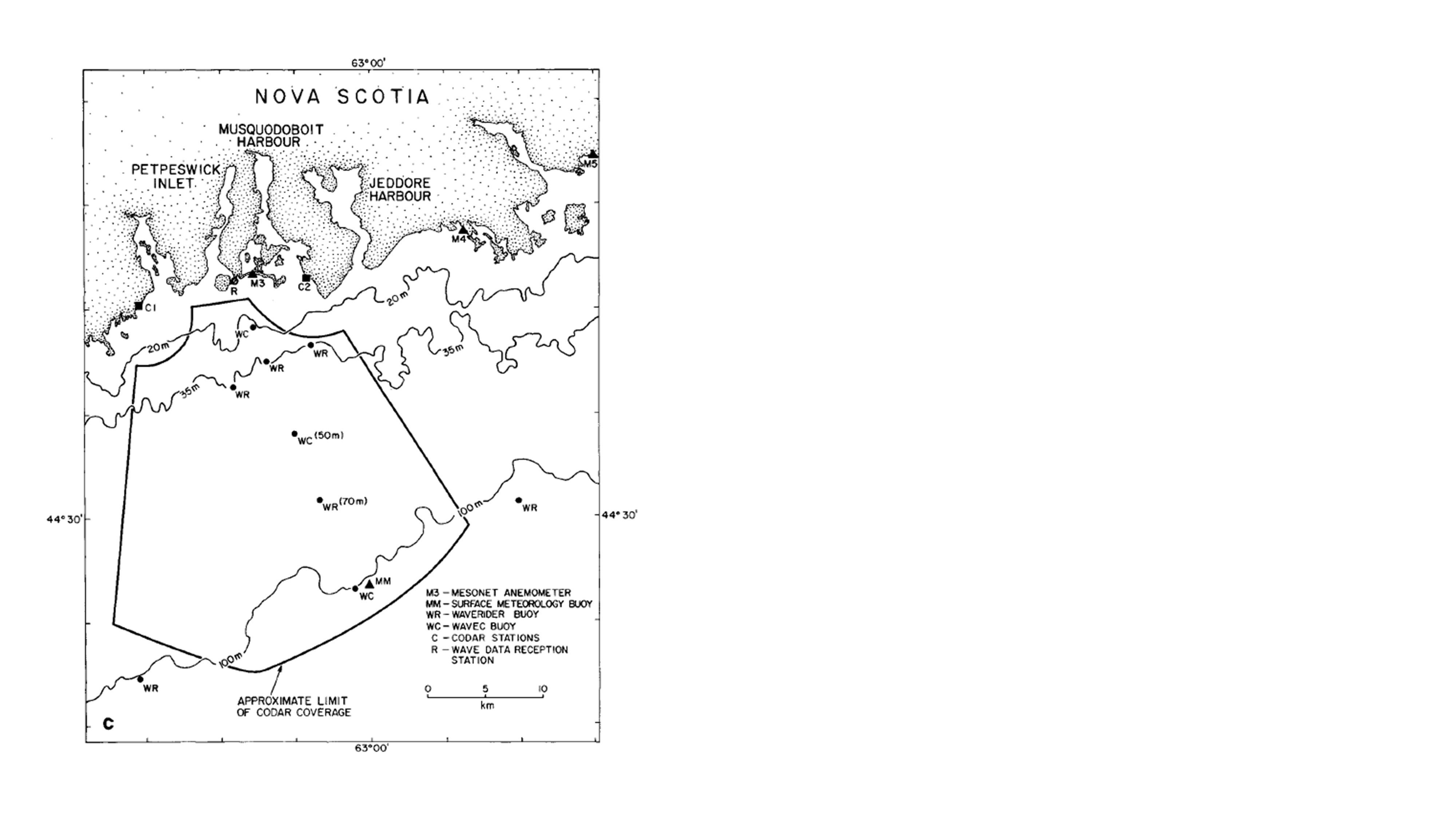
Eleven moorings were deployed in CASP-I to measure current, bottom pressure and water properties on the inner shelf east of Halifax. Mooring locations were chosen to detect variability on horizontal scales of 10 to 120 km, and the instruments on each mooring were concentrated around the pycnocline (40-70 m) with at least one instrument in the surface and bottom layers. Coastal sea level observations were made at ten sites regularly spaced along the Nova Scotia coast, and conductivity-temperature-depth (CTD) surveys were conducted on the eastern half of the Scotian Shelf during the mooring deployment and recovery cruises (about 1 December 1985, and 1 April 1986). The surface wave field east of Halifax was measured by three directional wave buoys and six conventional wave buoys (Datawell WAVEC and 0.9 m WAVERIDER, respectively) anchored shoreward of the 100 m isobath (within 30 km of shore). Water depth in the wave array ranged from 22 to 100 m, which was deep water for all fetch-limited, offshore-propagating waves. The WAVEC buoys and two of the WAVERIDERs were located on a line extending seaward normal to the coast, with the four remaining WAVERIDERs from 5 to 20 km on either side of the line. Within the wave buoy array, high-frequency ground-wave radar (CODAR) was used to produce hourly maps of the surface current field during selected storms. The coastal leg of the mesonet array provided wind measurements about every 15 km adjacent to the wave buoy and current meter arrays. Surface meteorology buoys were placed on the Scotian Shelf.
During the field phase, 16 storms (Intensive Observing Periods or IOPs) were sampled with a number of mesoscale features such as fronts, precipitation bands, heavy snow, and freezing precipitation. A number of the storms underwent rapid deepening, some produced heavy snowfall, and all produced freezing precipitation. Many of these storms had also been previously sampled over the United States as part of the GALE Project.
During the field phase of CASP-I, a special forecasting center was operated. In addition to the regular forecast tools, this office was equipped with graphical displays to present a number of products including special numerical guidance information. This office also had real-time access to 3-h rawinsondes, mesonet data, radiometer data, and special observer reports. As a result of operating this office, the forecasters developed a great appreciation for the requirements of future mesoscale forecasting. They felt that a single powerful workstation capable of assimilating and displaying products from a number of sources was essential. This must be coupled with the necessary communications links. They also pointed out that the types of observations must be appropriate to the nature of the phenomena and that sites for such observations must be well-chosen to maximize the usefulness of the data to the forecaster.
| Aircraft | DC3; Twin Otter; DND Aurora; Ice reconnaissance aircraft |
| Chemistry | Aircraft (filter, cloudwater, and precip samples); CAPMoN site filter, cloudwater, and precip samples); Provincial precip chemistry sites; Special CASP-I precip data |
| Model | Finite element forecasts (‘Continental’ and ‘CASP’ models); ARMF experimental model |
| Model | Routine AES/CMC analysis and forecast fields |
| Radar | Halifax and Trepassey 5-cm; Sable Island 10-cm |
| Radiometer | Shearwater site |
| Oceanography | Canadian and U.S. ship reports; Ice observations |
| Oceanography | Coastal tide gauges; CODAR data; WOTAN data; Current meter; Hydrographic (CTD) data |
| Oceanography Buoy | BIO MINIMET; NOAA Buoy; C-MAN platform; AES METOCEAN and PETROCAN HERMES; wave buoys |
| Satellite | GOES imagery (VIS and IR) and RAINSAT analyses; NOAA Polar Orbiting (imagery, TOVS); and NIMBUS SIMMR |
| Surface | Canadian Climate Centre hourly data and special reports; U.S. hourly data; |
| Surface | CASP-I mesonet data (26 towers) |
| Surface | Shearwater site (standard met obs, PMS, ceilometer, snow photos) |
| Upper Air | Standard AES stations in Ont., Que., and Atlantic Prov. |
| Upper Air | Special CASP-I soundings (AES, Beukers, DND GMD, Gadus Atlantica CLASS and Airsonde) |
| Upper Air | GALE Sounding Data Set |
Further information and details on the meteorological component of CASP-I can be found at:
Stewart, R.E., 1991: Canadian Atlantic Storms Program: Progress and plans of the meteorological component. Bull. Amer. Meteor. Soc., 72, 364–371. https://doi.org/10.1175/1520-0477(1991)072<0364:CASPPA>2.0.CO;2
Further information and details on the oceanographic component of CASP can be found at:
Anderson, C., F.W. Dobson, W. Perrie, P.C. Smith, B. Toulany and F.B. Schwing, 1989: Storm response in the coastal ocean. EOS, 18, 562-563, 570-572. https://doi.org/10.1029/89EO00142
Data Manager
- EOL Archive, NCAR/EOL/DMS