BASE
Beaufort and Arctic Storms Experiment
The Beaufort and Arctic Storms Experiment (BASE) was a Canadian-led international field campaign conducted to collect information on the structure and evolution of mesoscale weather systems, their clouds, and their impact on the regional climate over the southern Beaufort Sea and the Mackenzie River delta of the western Canadian Arctic. The experimental region extended approximately from 60N to 75N latitude and from 210E to 230E longitude. A combination of two aircraft, two Doppler radars, enhanced rawinsonde and other surface weather observations made measurements in the region from 1 September through 26 October 1994.
The BASE project was organized by the Atmospheric Environment Service (AES) of Canada and the University of Toronto (UT). Other foreign organizations, including Hokkaido University (HU) of Japan, the National Center for Atmospheric Research (NCAR) of the United States, and the Central Aerological Observatory of Russia, also participated in the project. BASE was primarily conducted out of Inuvik and Tuktoyaktuk. Other university participants included the University of Northern British Columbia (UNBC) and the University of Colorado (CU).
 |
Scientific Objectives:
The characteristic feature of a Pacific origin weather system is a pronounced layering of the air masses. In the upper layer, the air mass is of Pacific origin and is associated with a deep low in the Gulf of Alaska. As a result, it is moist and is capable of producing precipitation. In contrast, the lower layer is initially of continental origin and is associated with a secondary lee cyclogenesis event in the Mackenzie River basin. As the secondary disturbance moves to the east, there is a shift in the wind direction that advects air from the Beaufort Sea into the lower layer. This results in a moistening of the lower layer that allows precipitation from the upper layer that had previously evaporated in the lower layer to be enhanced and reach the surface. The detailed structure of this type of storm is strongly affected by the topography of the region and the presence of open water in the southern Beaufort Sea.
The storm track weather system is markedly different and is associated with the passage of a mesoscale low over the southern Beaufort Sea. In this sort of system, there is a well-defined frontal structure of a type previously identified in the midlatitudes. Two different precipitation regimes are identified that are associated with the passage of the warm and cold front. In this sort of system, the sources of moisture are the Bering Sea and the open water in the southern Beaufort Sea.
Thus, the primary objective of BASE was to improve the prediction of weather systems in the region and to improve the understanding of the role that these weather systems have on the climate of the western Arctic. In addition, BASE also addressed the implications that these systems have on the climate of the region. The impact of cloud systems and their micro and mesoscale processes on the climate is one of the issues that was being addressed by the World Climate Research Programme (WCRP)’s Global Energy and Water Cycle Experiment (GEWEX). The discharge from the north-flowing rivers that drain into the Arctic Ocean is important in (1) maintaining the pycnocline in the Arctic Ocean; (2) regulating sea ice production; and (3) regulating deep oceanic convection in the Nordic Sea.
Observations:
The BASE experimental region was situated between the mountainous region of the west coast of the North American continent and the central plateau region of the Canadian Shield. The Richardson Mountains (with an elevation exceeding 1000 m) extend along the southwestern part of the region. A flat low-level plateau extends eastward with the Mackenzie River along its western edge. The delta is a maze of meandering small channels. Uncountable lakes, swamps, and marshes are spread over the plateau and delta (see maps of the region below):
 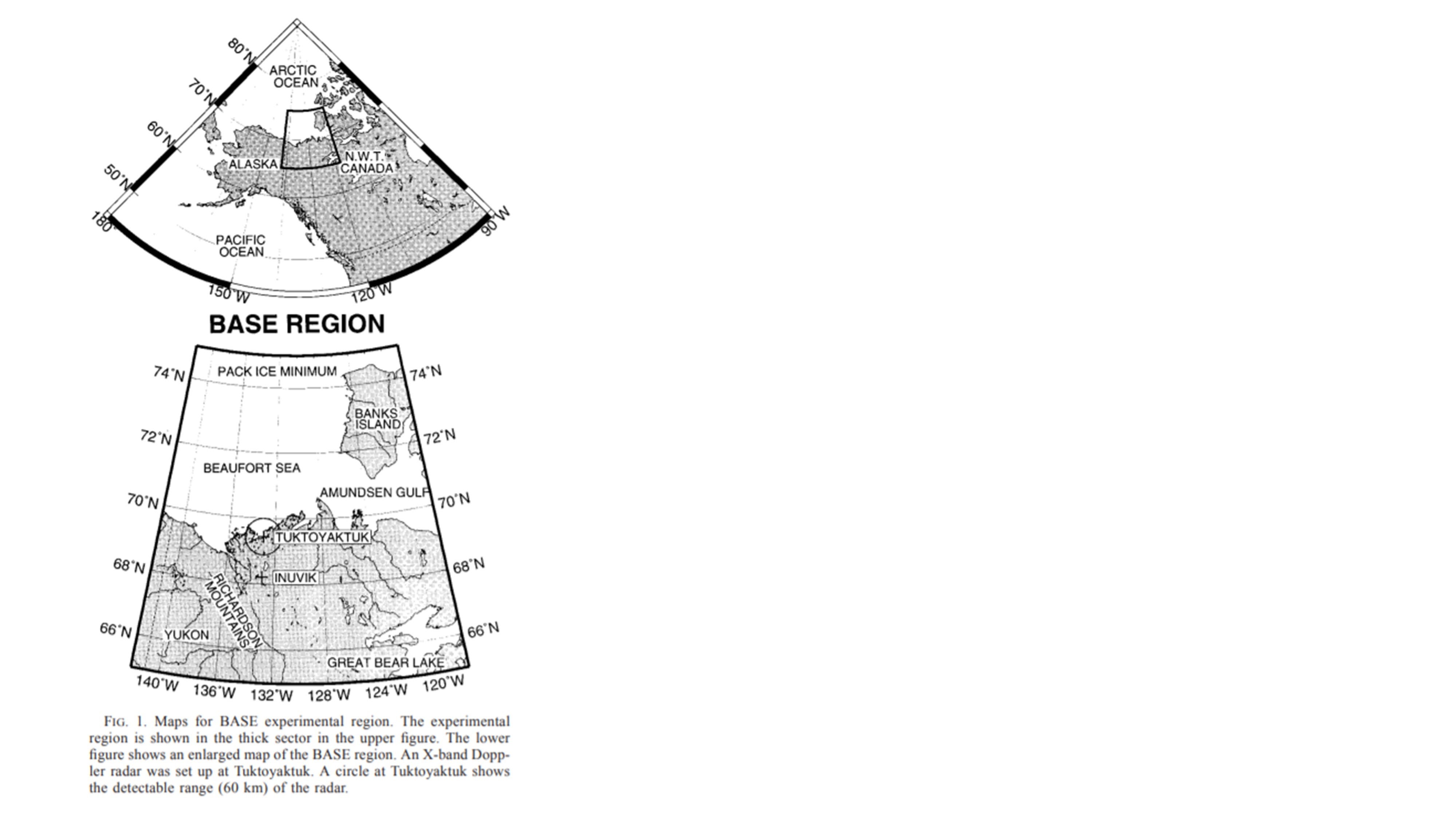 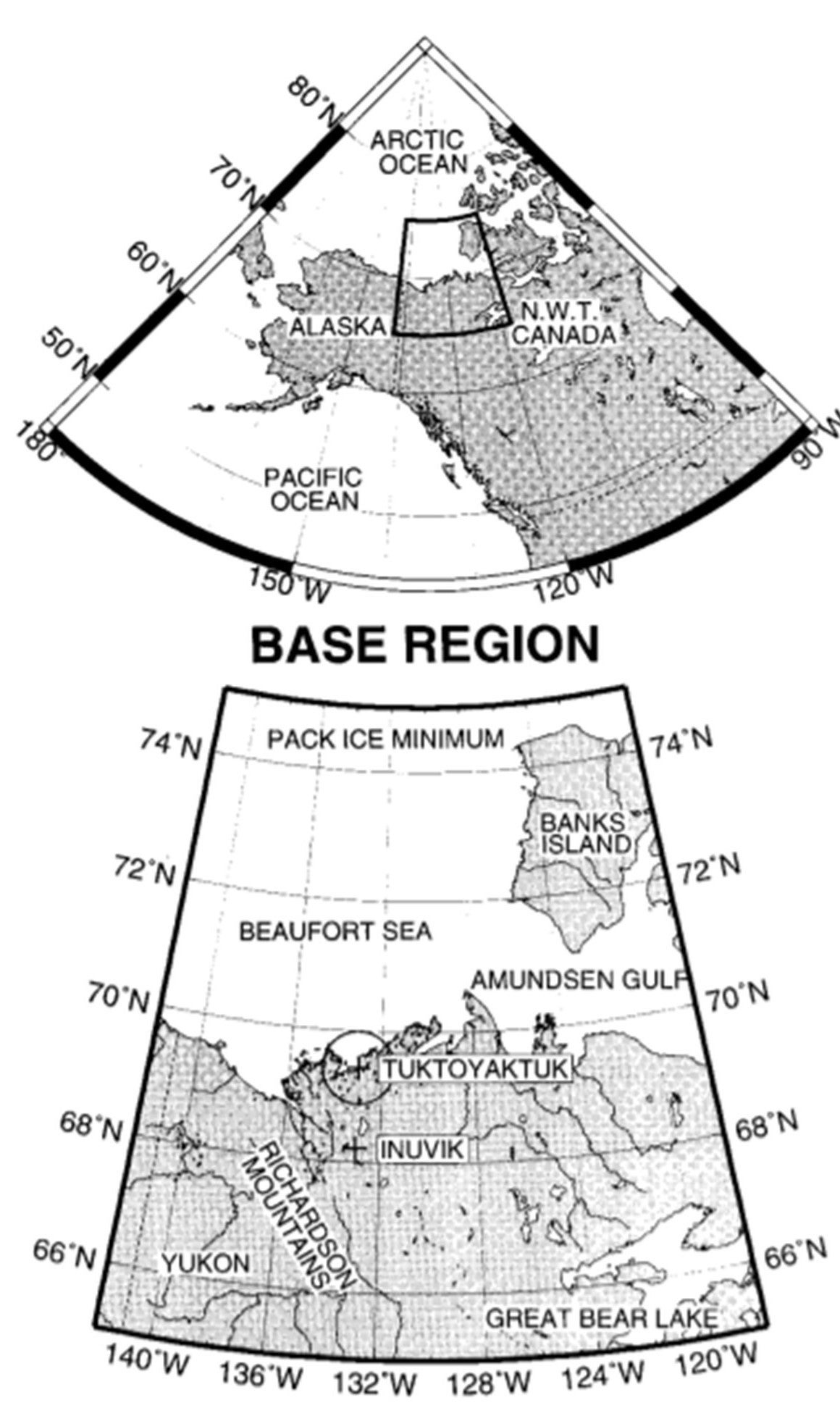 |
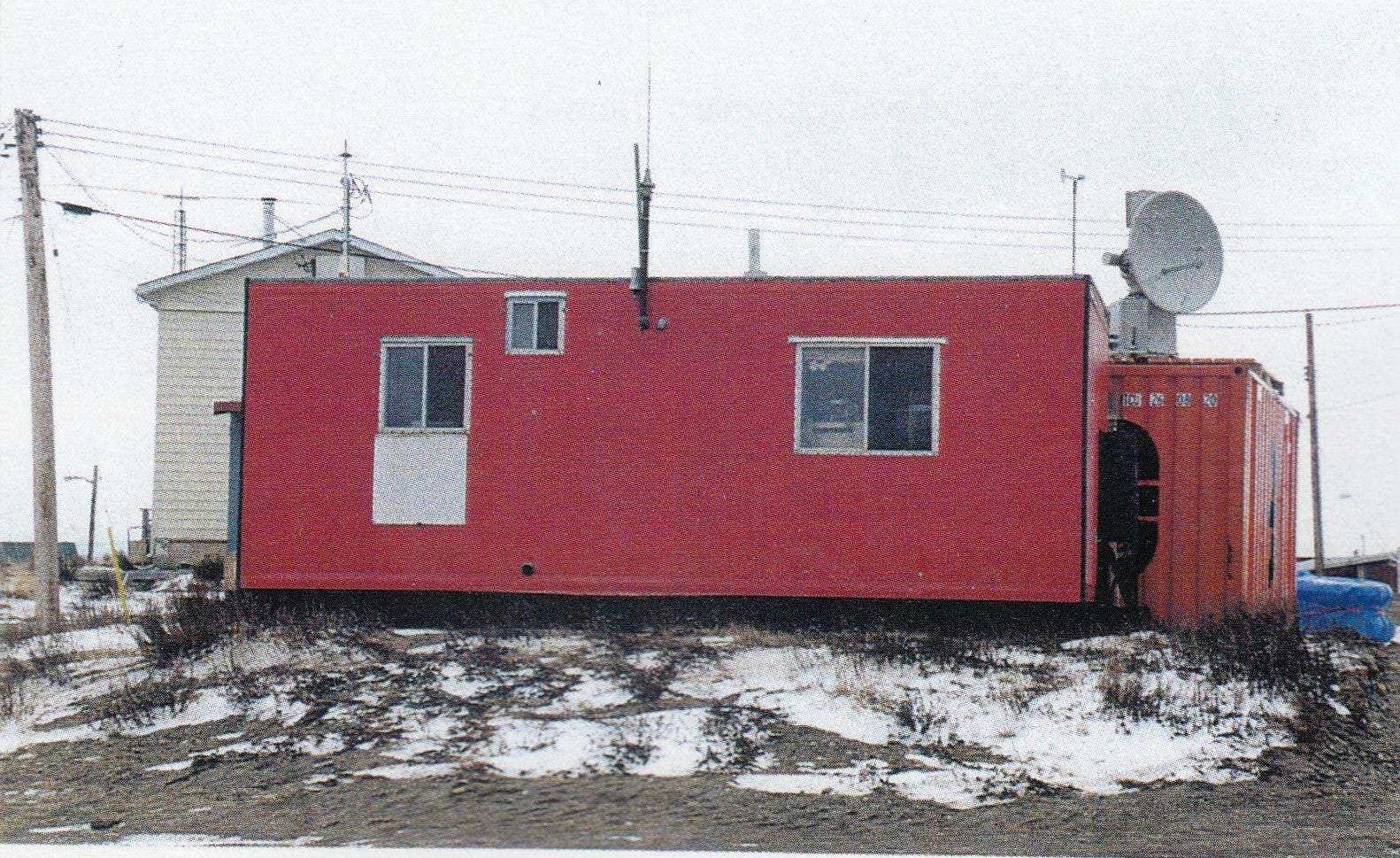
The main research assets for BASE were two aircraft [the Convair 580 of the National Research Council (NRC) of Canada, and C-130 of NCAR] and two X-band Doppler radar systems (Hokkaido University and University of Toronto). The X-band dual-polarization Doppler radar (wavelength: 3.2 cm, peak power: 40 kW, antenna diameter: 1.2 m) on the seashore of Beaufort Sea at Tuktoyaktuk was set up by Hokkaido University. Plan position indicator (PPI) data of reflectivity and Doppler velocity at four different elevation angles (18, 38, 58, and 108) were collected every 10 min. The University of Toronto and the AES operated an EEC LARS-88 X-band Doppler Radar at Inuvik. Nine Mesonet stations were set up near the radar sites by Hokkaido University and AES. Intensive upper-air observations were also conducted by the AES at Tuktoyaktuk, Inuvik, Norman Wells, and Whitehorse. Satellite images were received by the University of Toronto at Inuvik using a portable satellite receiver. The objectively analyzed dataset (GANAL) was provided by the Japan Meteorological Agency (JMA).
 |
The NCAR C- 130 aircraft flew 14 research flights during a 5-week period beginning 21 September and ending 26 October 1994. The flights were conducted within the BASE domain, with missions flown over sea ice of varying concentrations and open water. Flight patterns consisted of vertically stacked, 10 km legs flown at several heights within the cloud layer. Additional 10 km legs were typically flown above and below the cloud layers. Vertical profiles were obtained through slow ascents/descents, either by spiral or, more commonly, slant profiles. The ascent/descent rate was typically about 5-8 m per s, so the profile through a typical cloud layer of 300 m depth covered a horizontal distance of about 4.5 km. During BASE, a total of 40 individual cloud layers were sampled at various heights in the atmosphere. The Canadian NRC Convair 580 flew 14 research flights during the Period 4 September through 6 October, 1994.
Data:
During the primary BASE period (1 September through 13 October), 13 Intensive Observation Periods (IOP)s were conducted. IOPs were defined by the period encompassing the enhanced rawinsonde releases made for BASE and the NRC Convair Research flights during storm events. Details of each IOP and the synoptic weather conditions for each day can be found here. Facilities and datasets produced by BASE are provided in the following table.
| Aircraft | Canadian NRC Convair 580; NCAR C-130 |
| Model | AES Mesoscale Compressible model (MC2); AES Regional Finite Element model (RFE); Objective analysis dataset (GANAL) was provided by JMA |
| Radar | Two X-band Doppler radar systems (Hokkaido University and University of Toronto) at Tuktoyaktuk and Inuvik, respectively |
| Satellite | UT Satellite receiver at Inuvik [Advanced Very High Resolution Radiometer (AVHRR), TIROS Operational Vertical Sounder (TOVS)] |
| Surface | Nine special automated weather stations (AES); Four temperature and accurate pressure monitoring stations (UNBC); Inuvik precipitation chemistry station (HU); Inuvik Precipitation Photography (AES) |
| Upper Air | Convair 580 Dropsondes; 6 AES rawinsonde sites |
Further information and details on BASE can be found at:
Pinto, J. O., J. A. Curry, and J.M. Intrieri, 2001: Cloud‐aerosol interactions during autumn over Beaufort Sea. J. Geophys. Res., 106( D14), 15077– 15097, doi:10.1029/2000JD900267.
Principal Investigators:
- Judy Curry, et al.
Project Manager:
- Bruce Morley NCAR/EOL
Data Manager:
- EOL Archive NCAR/EOL/DMS