AVAPS Dropsonde System
The AVAPS™ (Airborne Vertical Atmospheric Profiling System), also known as the AVAPS™ Dropsonde System, has dramatically extended the envelope of atmospheric profiling capabilities. Since its debut in 1996, it has flown on numerous missions in support of operational weather forecasting and atmospheric research, with impressive results.
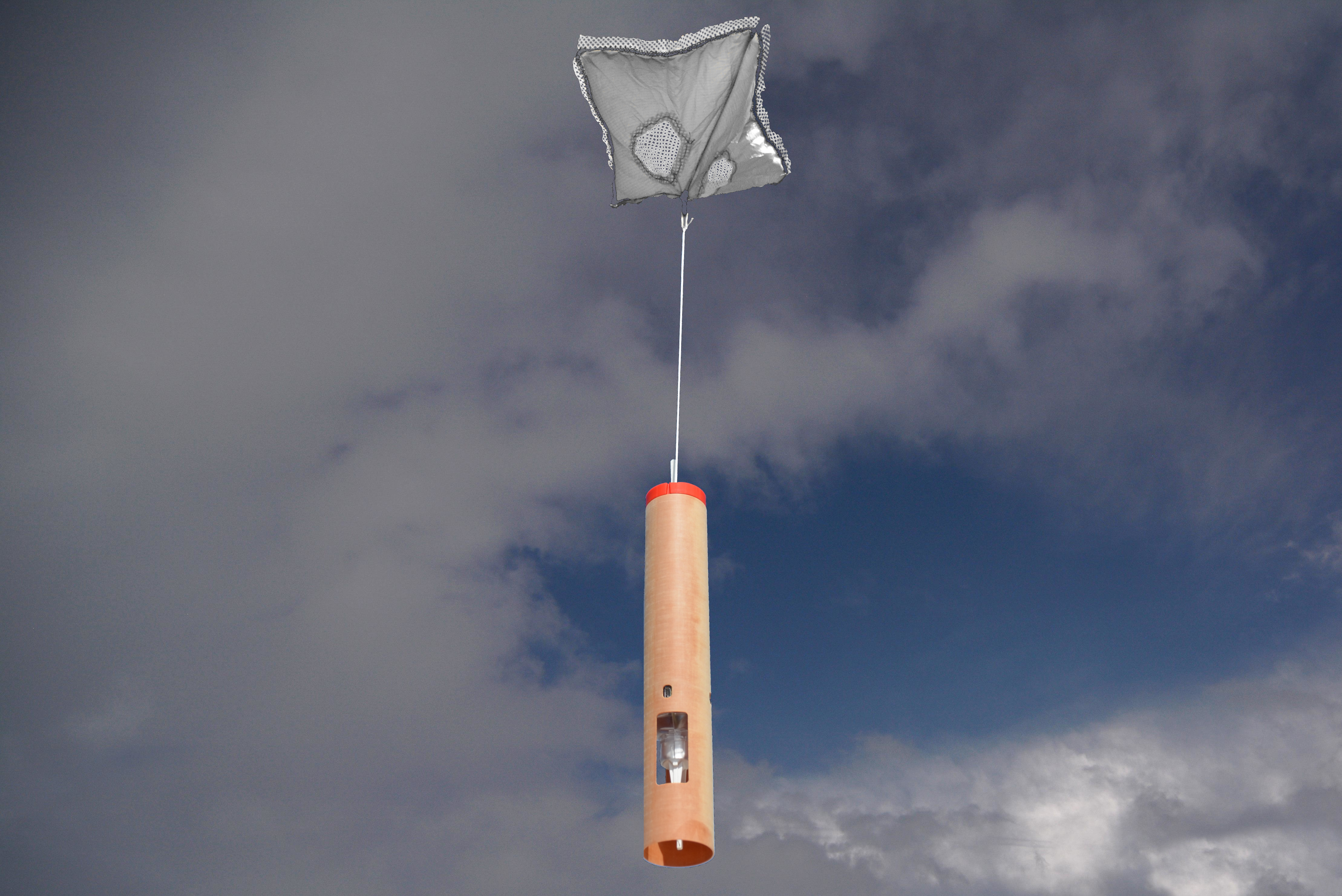
Aircraft launched dropsondes are released into the heart of storms to gather critical data. Photo: Holger Vömel
The AVAPS Dropsonde System is a critical atmospheric instrument that measures high-resolution vertical profiles of ambient temperature, pressure, humidity, wind speed, and wind direction. Measurements are taken by a parachuted GPS dropsonde that is launched from the aircraft and descends to the surface. High accuracy sensors provide in situ data, which the dropsonde transmits in real-time back to the data system onboard the aircraft.
Dropsondes provide the ability for targeted observations over remote areas such as the oceans and polar regions, which are not possible otherwise. They also provide a means to obtain soundings in and around severe weather systems, such as hurricanes. Atmospheric soundings obtained from dropsondes during hurricane reconnaissance flights dramatically improve the accuracy of hurricane landfall forecasts.
Overview
The sonde is a small electronic device that contains atmospheric sensors: pressure, temperature, humidity, and a GPS receiver to derive winds. The sonde is launched from an aircraft where a parachute is deployed. As the sonde descends to the Earth's surface, it continuously measures the state of the atmosphere and telemetries this information to the research aircraft. The aircraft is equipped with dedicated hardware and software to process the signal from the sonde in real-time to display and archive the data. Once the sonde has reached the surface, all data collected during the descent is sent via satellite to atmospheric research centers, the National Hurricane Center, or the World Meteorological Organization's dedicated data centers.
Dropsonde Description
The dropsonde composed of a small electronic circuit board, sensors, and a battery housed in a cardboard tube with a parachute. The inner electronic components of the dropsonde consist of precision temperature, pressure, and humidity sensors, low powered telemetry transmitter, GPS receiver, and a microprocessor. As the sonde descends, it continuously measures the atmosphere from the release altitude to the Earth's surface. Measurements are made every half second, which provides a detailed profile of the atmosphere. The parachute deploys from the top of the sonde within seconds of being released from the aircraft. The parachute is specially designed for high reliability and a very stable descent. As the sonde descends, the GPS receiver tracks the position and velocity of the sondes. This change in motion corresponds to the atmospheric winds. The sensor data, GPS receiver 3D position and 3D velocity, along with engineering health of the sonde, is all wirelessly sent via radio waves to the aircraft with a low-powered transmitter operating in the 400-406 MHz Meteorological band.
In addition to the sensor module and the GPS receiver module, the dropsonde electronics board includes a microprocessor for measuring and controlling the sensor module and sending the data to the 100 milliwatt 400 MHz telemetry transmitter and a lithium battery pack for power. Surface mount technology is used on the electronics board to reduce the size and increase the ease of manufacture. In addition, the electronics board contains a connector that serves as an RS-232 link with the aircraft data system for test and checkout and for setting the telemetry transmitter frequency prior to deployment. The transmitter can be set anywhere in the 400-406 MHz meteorological band in 20 kHz steps, creating about 300 separate channels.
A unique square-cone parachute is used to reduce the initial shock load and slow and stabilize the sonde. The parachute is immediately deployed on exit from the launch chute and streamers for about five seconds until filled by ram-air. The stability of the square cone parachute is very good during the sonde's descent and eliminates any pendulum motion of the sonde.
UCAR has licensed Vaisala Inc. of Louisville, CO, to build the NSF NCAR GPS Dropsonde, as Vaisala model RD41.
Users of the NCAR GPS Dropsonde system (AVAPS)
NOAA
ISF has built a "double" 8-channel AVAPS system plus spares for the NOAA G-IV and two additional data systems plus spares for the two NOAA P-3's. These systems were delivered to NOAA in August 1996 for testing and use, and have since been used in numerous research programs as well as operational forecasting of tropical and winter storms.
USAF Reserve Hurricane Hunters
ISF has built 10 AVAPS systems plus spares for the 53rd Weather Reconnaissance Squadron (aka Hurricane Hunters) at Keesler Air Force Base in Biloxi, Mississippi. These systems are operational in their WC-130J aircraft. During a typical hurricane season, the 53rd deploys 1000 to 1500 sondes on storm missions and during training flights.
NCAR
NCAR has two AVAPS systems, which can be used on the NSF/NCAR C-130 and the NSF/NCAR G-V.
University of Wyoming
The University of Wyoming operates one AVAPS system on the NSF/UWYO King Air.
NASA
NASA has two AVAPS systems, which can be deployed on a number of NASA research aircraft (King Air, DC-8, P-3).
DLR
AVAPS systems have also been built for DLR in their Falcon and Gulfstream G-550 research aircraft.
Other research institutions
UCAR has licensed Vaisala to sell the AVAPS system to their customers worldwide. AVAPS system have been installed in several of NASA's research aircraft, in the United Kingdom Meteorological Office's BAE-146, and in aircraft of many other research institutions worldwide for targeted observations in remote locations.
See Also
When referencing the NCAR Airborne Vertical Atmospheric Profiling System (AVAPS) in publications or proposals, please use the identifier 10.5065/D66W9848 -- for example as a citation:
NSF NCAR Earth Observing Laboratory. (1993). NCAR Airborne Vertical Atmospheric Profiling System (AVAPS). NSF NCAR Earth Observing Laboratory. https://doi.org/10.5065/D66W9848
Please be careful of line breaks when cutting and pasting the above text, and feel free to reformat to fit your document. Additional citation styles are available at DataCite or CrossCite.
Additionally, please cite the First Use paper associated with this Facility/Instrument:
Hock, T. F., Franklin, J. L. 1999: The NCAR GPS Dropwindsonde. Bull. Amer. Meteor. Soc., 80, 407-420.