The Cold Pool experiment aimed to characterize the lowest levels of the stable boundary layer across valleys of varying widths to understand terrain influences on cold pool development and dissipation in the Pennsylvanian Appalachian Mountains. All observational resources available to Millersville University SEAR-MAR participants were used, including the University of Wyoming King Air (UWKA) Research Aircraft, LiDAR, SoDAR, 10-meter flux tower, and radiosonde systems.
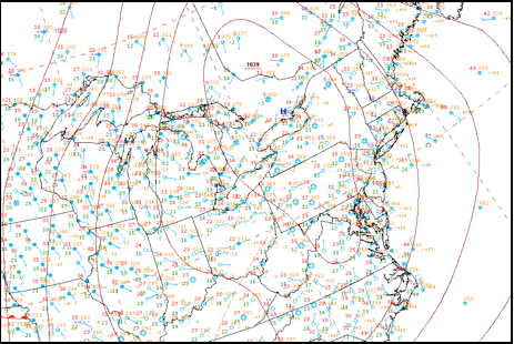
A climatological study of frontal passage types indicated that approximately two frontal systems would be observed during the active SEAR-MAR project phase. With similar frequency, high pressure centers or cold air damming signatures were expected to occur. The ideal synoptic requirements for the Cold Pool experiment included a weak surface pressure gradient, ideal radiational cooling the evening prior, and calm surface winds. Two of three conditions were met (Fig. 17): light winds existed in the Susquehanna Valley (KMDT, KLNS) but frequently ceased in the nearby valleys, including at Selinsgrove (KSEG), Altoona (KAOO), and even Muir Army Airfield (KMUI).
The Cold Pool experiment design revolved around the capabilities of the UWKA. The objective was to explore the boundary layer in a wide valley and narrow valley case. To observe below the 1,000 ft. AGL flight minimum, regional airport accessibility was a major factor in valley selection. Therefore, the Cumberland Valley (Franklin County Regional Airport (N68)) and the valley containing Bendigo Airport (74N) were chosen. The flight path is shown in Figure 18. Meanwhile, a Windsond launch team launched two radiosondes: one in an intermediate width valley (near Pine Grove, PA) and one in conjunction with the Schuylkill County Airport (KZER) missed approach.
Also, the flux tower, LiDAR and SoDAR measurements were to be used to describe the relatively flat environment to the south and east of the target valleys.
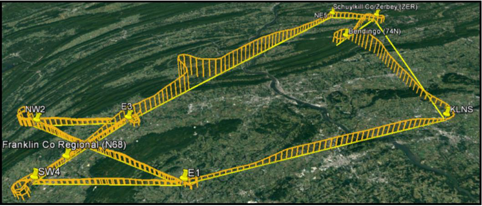
The Cumberland Valley was interrogated with the UWKA using an hourglass pattern to obtain along-valley and cross-valley characteristics at various altitudes (1,000, 1,300 and 1,600 ft. AGL). Along the entering and exiting along-valley tracks, a missed approach was included to measure the near-surface environment down to 50 ft. AGL. Upon exiting the Cumberland Valley, in transit to Bendigo, an aircraft sounding to 7,000 ft. was executed.
Two missed approaches were incorporated into exploring the Bendigo Valley. KZER presented an opportunity to measure the ridgeline near Bendigo Airport as it lies overlooking a steep slope of a similarly sized valley approximately 24 km (15 miles) to the northeast. The second Windsond launch was executed from the valley floor beneath KZER concurrently with the missed approach. From KZER, the UWKA proceeded to complete a missed approach of the narrow valley floor at Bendigo Airport followed by a sounding up to 7,000 ft. The aircraft then returned to base.
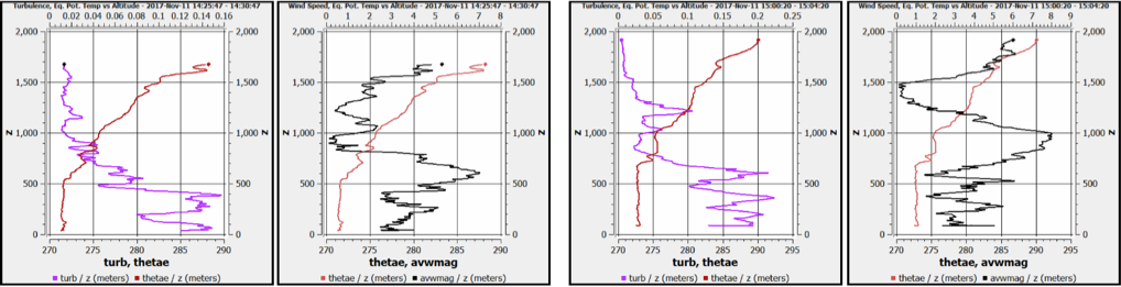
Some preliminary findings were extracted from the sounding data. The lowest portions of the boundary layer in the valley appear to have mixed by the interrogation period. However, a stable, supergeostrophic wind maximum (Fig. 19) – a northerly valley-parallel low-level jet was observed along the ridgeline above the cold pools. The structure, formation and evolution of this wind maximum has excited interest in the student group and the subject of investigation.