P3 Flight Log:
- Lear scheduled for an 11:00 am takeoff, NRL P-3 for 12:00, and the NOAA P-3 for 1:00 on a squall line system in southeast Oklahoma. Forecasts were for possible redevelopment in western Oklahoma if this initial squall line died. Lear took off at 10:30 since an MCV was apparent. The P-3 delayed one hour to watch the evolution of the system. There was an oil problem in one of the engines, which delayed our takeoff by 40 extra min, Takeoff time was 1:40 pm (1840 UTC). When we arrived in Arkansas, the original squall line had developed a hook shape/MCV appearance with multiple rainbands. We decided to choose one of the primary rainbands east and southeast of the MCV to fly box-type patterns around the rainband. The band was composed of stratiform precipitation with a prominent bright band at approximately 10,000 ft. The pattern provided a good test of working with the Navy pilots as we navigated around the band. Wen-Chau Lee, Mike Bell, and Hanne Murphey also took turns as the Mission Scientist to gain some experience flying on the P-3. We noted significant convergence in the band (winds strong westerly on the westside and weaker westerly on the eastside). One of the box patterns suggested that there was a significant cyclonic shift of the winds across the band. The band began to weaken and the Ops Center released us at 5:15 pm to fly back to St Louis. We landed at 6:29 pm CDT (2329 UTC). We first descended to 3,000 ft. AGL as we approached the MCV but had to ascend to 4,000 ft. when we went IFR so that ATC's radar could track us. ELDORA had one period when it went down. The guess was that it was too hot in the cabin so the pilots attempted to turn up the air conditioner. Everything else worked, however, the filter that was installed to stop the interference between the iridium satellite phone and the WSI radar feed did not appear to work. This is a concern since the pilots and the Mission Scientists want the WSI display but that means all communications with the Ops Center must terminate (no tracks, no satellite voice communication, no chat room). This is a serious problem that I hope will have a solution soon. One several occasions, when we started the data link, the refresh time for the WSI was at least 15 minutes. The good news, however, is that the VHF radio is now working and Hanne did not encounter any problems contacting the NOAA P3 and the Learjet.
- 5/24/2003 A MCS developed overnight moving from west central Kansas into Oklahoma. The convective part of the system weakened around the P3 takeoff time at 1 pm. NRL P3 takeoff was delayed by 30 min due to a minor engine problem. Charlie fixed a network problem on the WINS display at the science station before takeoff. The IP is southwestern Arkansas, in front of the MCS system. The MCS did not have active convection at the time of NRL P3-s arrival about 2:30 CDT. The rainband exhibited a bow shape structure but there were all stratiform rain with the peak reflectivity exceeding 40 dBZ. We repeatedly flew box pattern to observe this decaying rainband. It was quite obvious that there were speed convergence across the rainband. Although there was no active convection, this speed convergence might be the mechanism to keep the rainband alive. The WSI display clearly showed the MCS structure and became the primary navigation tool for this mission. The interference between the WSI and satellite modem remained a major problem. We thought the newly installed filter would solve most of the interfering problem before the flight. It turned out that WSI system got interrupted whenever the chat function was activated. Hence, the operation center could not receive flight track information as well. This is a serious problem for operation. It is hoped a solution can be found as soon as possible. The weak rainband system provided a perfect training opportunity for training purposes. After the first box pattern, Wen-Chau, Michael and Hanne got a chance to direct the NRL P3 during the mission. We accidentally led the aircraft into the heart of the rainband and encountered minor turbulence. We realized later that when WSI display is not updating, flight scientists have to rely on other data source such as the WARDS and ELDORA CAPPI to avoid hazard situation. The mission was terminated about 5:30 CDT and the NRL P3 returned to Midamerica airport at 6:40 CDT.
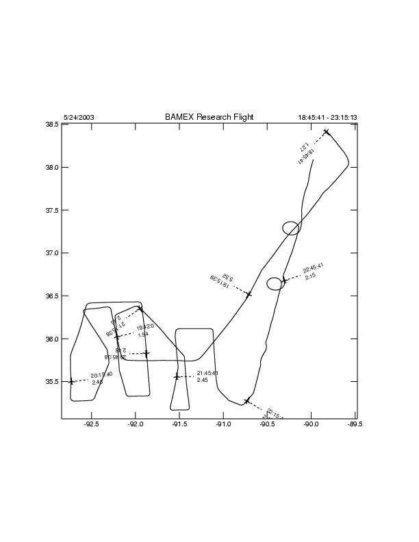
Flight Track:
ELDORA Images for this Flight:
(Hit submit to view images, and allow pop-up windows to view interactive flight track.)
