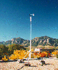
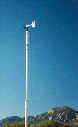
Station Location
The NCAR Foothills Lab weather station is located on a 6 meter tower which is on the roof of a 2 story building. The building is due east of a large highway overpass and near several other large buildings. Our wind speed readings tend to be lower than those from other nearby weather stations during heavy Westerly wind events. Weather is a very local phenomenon and we have our own micro-climate. Due to rooftop heating, temperature readings may read a few degrees high in low wind conditions.
Station Geographical Information
Latitude: 40 degrees 2 minutes 6 seconds
Longitude 105 degrees 14 minutes 35 seconds
Elevation 1625 Meters (5332 Feet)
NCAR Weather Station Contact
If you would like to get archived weather data from the NCAR weather stations, visit one of the links below and look for Data Availability near the bottom of the page, access to the data is explained there:
Foothills Lab Weather Station Info
Mesa Lab Weather Station Info
NCAR does not maintain data archives for any sites other than the two Boulder, CO. stations, if you need this kind of information, we suggest contacting the local newspaper office, the local airport, or the National Weather Service. The following link may also have pointers to sites that you may find to be useful:
If you have problems with the weather plots not updating on your web browser, try using the Reload button or even Shift + Reload, that usually solves the problem.
Before you send us email, be sure to read the Weather Station Info pages above, a lot of questions will be answered there.
Lastly, if the NCAR weather station data goes away, please don't send email, we're probably working on the problem already. We appreciate your concern nonetheless.
NCAR Foothills and Mesa Lab Weather Station Contact: wwweather@eol.ucar.edu
Weather Station Hardware
A Vaisala WXT510 weather transmitter is being used to collect all of the meteorological information. The WXT510 is a self contained weather station which provides an RS-232 data stream containing temperature, humidity, pressure, rain accumulation, wind speed, direction and peak gust speed.
Here is an overview of the WXT510 sensor specifications.
Data Transmission Hardware
 The RS-232 data from the weather station is run through a 1 meter fiber optic lightning isolation link then converted to RS-422 which is used to run the signal from the roof of the building into one of the offices below. There, it is converted to RS-232 again for connection to a Sun Microsystems Sparc 5 computer where it is ingested and made available to our web server machine on the net. The data transmission and isolation hardware was designed and built at NCAR.
Data Ingest Software
 The weather station's data stream is collected by a C program called weatherd (the weather daemon), stored in netCDF format files, then plotted using gnuplot which is run from a Perl script called cdf2gplot. Honorable mention should be given to the Zebra program, a very powerful multi-platform data ingest and display system which was used to get the original system up and running.
Data Filters
Wind Direction
The wind direction signal is not valid for zero wind speed and the data is removed from the plots in that situation to reduce the number of spikes.
Peak Gust
Here is a description of the Peak Gust calculation performed inside of the Coastal weather station.
Rain Accumulation
The rain accumulation data is a plot of "rain events" which are periods where the rain is actually falling. After an hour of no rainfall, the chart resets to zero. The total rainfall over a period of time is a sum of the individual rain events. The textual rain accumulation info at the top of the page represents total rainfall since midnight.
Derived Fields
Dewpoint
If the air were cooled down, the dewpoint would be the temperature where the moisture in the air would condense and form dew.
Here is formula for the derivation of dewpoint.
Aeronautical Pressure Correction
Pressure varies with altitude, as you move towards outer space, the pressure moves towards zero. Aeronautical pressure correction is used to remove the altitude information from pressure readings so that comparisons can be made between weather stations at different heights.
Here is formula for the derivation of corrected pressure.
Wind Chill
An NCAR meteorologist, Bob Rilling has put together this information on Wind Chill. We are currently using the Court method for calculating wind chill. Note that the wind chill is undefined for wind speeds below 1.9 meters per second and for temperatures above 33 ºC.
Data Availability
The NCAR weather station data is now available at our FTP archive We cannot offer any support for use of the data, please see the README file for details and caveats.
Reloading of Plots
If you bring this page up multiple times using most web browsers, you will probably have to select Reload Images from the File menu to get updated plots. If you are using Netscape, try using the "reload" button or "shift-reload" to get the latest images. Netscape has a reload bug that is related to daylight savings time, if you still can't reload, try going into the "Options" pulldown under "Network Preferences" and push "Clear Disk Cache Now", then press "reload.
A service of the NCAR Earth Observing Laboratory, brought to you by Gary Granger, Chris Burghart, Bob Rilling with help from John Militzer and Steve Oncley. The photography is by Forrest Cook.
Go back to the Foothills Lab weather page.
DISCLAIMER
The weather station is located on the roof of the NCAR Foothills Laboratory in North East Boulder, Colorado. The data is accurate for that location but the location is not perfect for meteorological data gathering. Wind speeds at this elevation may be higher than at ground level and there may be some wind shading due to other tall buildings in the vicinity. On days with no wind, the temperature may be artificially high due to heating of the roof. Finally, the RAINCAP sensor measures the momentum of precipitation, which is reliable for rain and to some extent hail, but not for snow, fog, dew, etc. This data is provided for non-scientific use as a public service to the community. NCAR and UCAR hold no responsibility for the accuracy of the data and bear no liability for the use of the data presented on these web pages.


