CEPEX
Central Equatorial Pacific Experiment
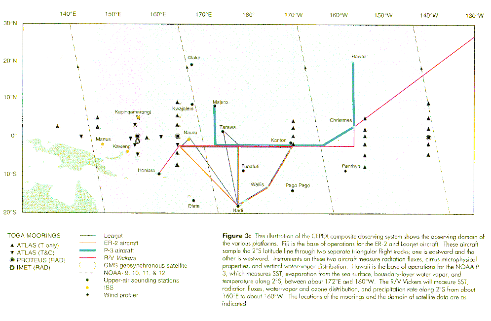
The Central Equatorial Pacific Experiment (CEPEX) was conducted in the Central Pacific Ocean from approximately 160 E to 150 W longitude and 20 N to 20 S latitude. This was the area of maximum sea-surface temperature (SST) gradient extending east-southeast from the Western Pacific "Warm Pool." The overall scientific goal of CEPEX was to establish the relative roles of cirrus radiative effects and surface evaporation in limiting maximum SST in this area.
(Click Image for Full Resolution)
Science Objectives
Specific experimental objectives included:
- To measure, by direct atmospheric observations, the vertical structure of the water vapor greenhouse effect
- To measure the effect of cirrus on radiation fluxes over the equatorial Pacific
- To measure the east-west gradients of SST and the evaporative and sensible heat flux from the sea surface along the equatorial Pacific
- To measure the east-west gradients of vertical distribution of water vapor along the equatorial Pacific
- To explore the microphysical factors contributing to high albedo of widespread cirrus layers
Project Operations
Special observations were made throughout this area from island stations, research buoys, the NOAA Research Vessel (R/V) Vickers and overflights by four research aircraft based at the Nadi International Airport, Fiji (NASA ER-2; Aeromet Learjet) and at the Barber's Point Naval Air Station, Honolulu, Hawaii (NOAA P-3; NCAR Electra). Besides standard meteorological, cloud physics, photography, and navigational measurements, special aircraft instrumentation included:
- remote sensors on the ER-2;
- radiation sensors and dropsondes on the Learjet;
- radiation sensors, C-band radar (lower fuselage), X-band Doppler radar (Tail) on the P-3; and
- radiation and ozone sensors on the Electra.
The CEPEX Field Operations Center was located at the Nadi International Airport, Fiji, and operations were conducted from 5 March to 7 April 1993. The cruise of the R/V Vickers departed Honiara, Solomon Islands on 7 March 1993 and docked at Christmas Island on 18 March 1993. Instrumentation on the R/V Vickers included a full suite of instrumentation collecting meteorological, radiation, rawinsonde, ozonesonde, lidar, interferometer, and various oceanographic measurements.
All photos copyright University Corporation for Atmospheric Research unless otherwise noted.
Principal Investigators:
- Dave P. Rogers, et al.
Project Manager:
- Paul Spyers-Duran NCAR
Data Manager:
- EOL Archive NCAR/EOL