CHEESEHEAD
Chequamegon Heterogeneous Ecosystem Energy-balance Study Enabled by a High-density Extensive Array of Detectors
SCIENTIFIC GOALS
The Chequamegon Heterogeneous Ecosystem Energy-balance Study Enabled by a High-density Extensive Array of Detectors (CHEESEHEAD) is an intensive field campaign designed specifically to address long-standing puzzles regarding the role of atmospheric boundary-layer responses to scales of spatial heterogeneity in surface-atmosphere heat and water exchanges. A high-density observing network will be coupled to large-eddy simulation experiments to advance spatiotemporal scaling methods for heterogeneous land surface properties and fluxes, evaluate realistic large eddy simulations in complex landscapes, and test theories on the scales at which the lower atmosphere responds to surface heterogeneity. The proposed experiment generates knowledge relevant to many scientific applications in the national interest such as numerical weather prediction, energy resources, and computational fluid dynamics. Field support outreach and teacher training is included via middle, high school, and undergraduate student involvement at nearby schools and colleges.
LOCATION
The three-month field campaign will be held mid-summer 2019 in a 10x10 km domain of the existing Park Falls, WI, WLEF 400 m very tall tower Ameriflux/NOAA supersite. The three-month period allows for observing the evolution of the land surface from latent-heat flux dominated to sensible-heat flux dominated as vegetation senesces sequentially across the landscape.
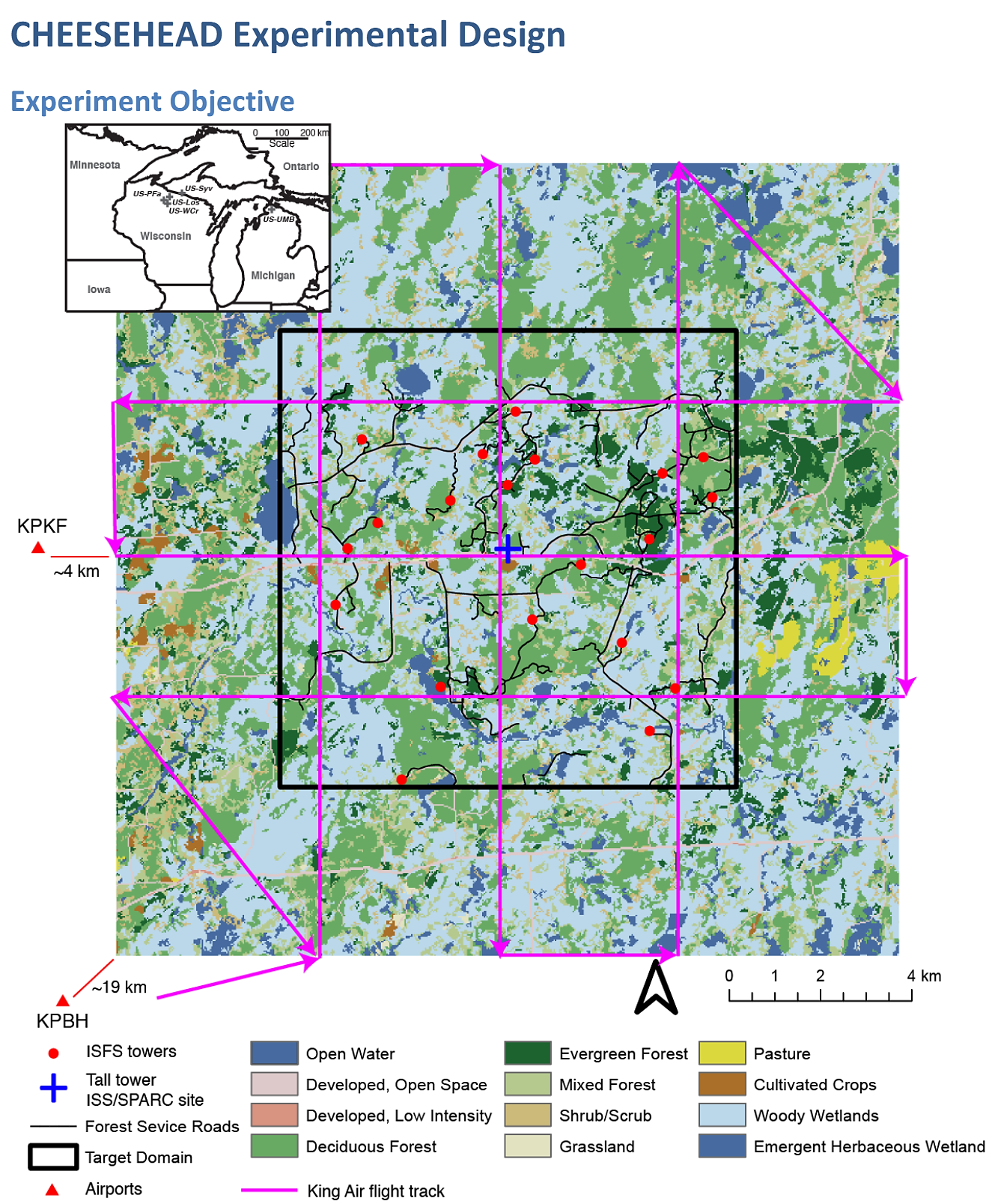 |
FACILITIES
Requested Facilities: UWKA with WCL, 1 NCAR ISS, 12 - 20 NCAR ISFS, NCAR WV DIAL, EOL Data Management, Operations Plan.
The project involves deployment of the National Science Foundation Lower Atmosphere Observing Facility (LAOF) Integrated Surface Flux System. This first-of-its-kind very high-density (17-20 tower) eddy covariance flux tower network would intensively sample surface energy fluxes and meteorology across a heterogeneous forest landscape representative of much of the mid-latitudes within the 10x10 km sampling footprint of the existing very tall tower. Student observers would routinely sample phenology and vegetation properties at the tower sites. A NASA G-LiHT airborne imaging spectroscopy campaign will map leaf chemistry, canopy structure, and thermal emission for scaling purposes. Atmospheric profiles will be observed at a clearing near the tall tower with the LAOF Integrated Sounding System 449 MHz profiler, radiosondes, the University of Wisconsin SPARC AERI, HSRL, ceilometer and wind LiDAR, and the contributed instruments from collaborators including additional wind LiDARs and in situ profiling on the tall tower. Three five-day intensive observation periods will include deployment of University of Wyoming King Air to map energy balance eddy fluxes, atmospheric profiles, and planetary boundary-layer depth. All of these observations would be used to test flux tower scaling, observe atmospheric mesoscale patterning, and evaluate large eddy simulations.
Principal Investigators
Ankur Desai (UW)
Mark Schwartz (UW)
Matthias Mauder (KIT)
Stefan Metzger (NEON)
Rosalyn Pertzborn (UW)
Data Manager
EOL Archive NCAR/EOL/DMS