MANITOU
Manitou Experimental Forest Observatory Data Collection from NSF NCAR ACOM Archive
DOI for this page: https://doi.org/10.5065/d61v5cdp
This is the NSF NCAR ACOM Manitou Data Archive that has been transferred to the NSF NCAR EOL Field Data Archive. It contains a variety of data collected during twelve field campaigns from the Manitou Experimental Forest Observatory site. Data included in this archive are from the BEACHON-ROCS2010, BEACHON-RoMBAS2011, BEACHON-SRM2008, MANITOU2008, MANITOU2009, MANITOU2011, MANITOU2014, MANITOU2015, MANITOU2016, RXBURN2015, SPIFFY2015, and SPIFFY2016 field campaigns.
The Bio-hydro-atmosphere interactions of Energy, Aerosols, Carbon, H2O, Organics & Nitrogen (BEACHON) project was initiated by the National Center for Atmospheric Research (NCAR)as well as research collaborators from the university community to investigate ecosystem-atmosphere exchange of trace gases and aerosols and their potential feedbacks between biogeochemical and water cycles. One of the project’s primary objectives is to improve the predictability of earth-system models over time scales ranging from minutes to decades. BEACHON is now an ongoing component of atmospheric research sponsored by the National Science Foundation. This interdisciplinary research program integrates local and regional model simulations with remote sensing, regional network observations, and canopy- to regional-scale field measurements. BEACHON includes investigations of atmospheric, ecological and hydrological processes including concentration and flux measurements of energy, CO2, H2O, volatile organic compounds, aerosols, nitrogen compounds, hydrological parameters and feedback processes that are relevant to atmospheric chemistry. Rocky Mountain ecosystems are important for providing water and other resources in the western United States, but contain only a limited number of long-term monitoring sites. This region is predominantly arid or semi-arid resulting in biogeochemical cycles that are water-limited. Since the area contains some of the fastest growing population centers, water limitations (combined with a climate that is projected to be warmer and potentially drier) pose significant societal vulnerabilities (Vorosmarty et al., 2010).
The Manitou Experimental Forest Observatory (MEFO) was established in 2008, in an area representative of a middle-elevation (~2000 - 2500 m ASL). It is a semi-arid, ponderosa pine ecosystem that is common throughout the Rocky Mountain West, but not adequately characterized.
Objectives:
- Collect long-term measurements of meteorology, water, carbon dioxide (CO2), and energy fluxes, aerosol size distributions and fluxes, trace gas and cloud condensation nuclei concentrations;
- Monitor soil moisture, precipitation, snowpack, stable water isotopes, and other hydrological variables to provide input and lateral boundary conditions for Earth-System models and as a basis for making more accurate water resource predictions for this and other semi-arid regions;
- Provide infrastructure for collaborative research among government laboratories, universities and private companies;
Carry out intensive measurement campaigns; - Provide training for undergraduate and graduate students and promote multidisciplinary research.
Related Overview Publications:
- Overview of the Manitou Experimental Forest Observatory: site description and selected science results from 2008 to 2013
- A Summary of Research at The Manitou Experimental Forest in Colorado, 1937 - 1983
Quick facts:
Location: 39.1006° N, 105.0942° W, 7700 feet ASL (2347 m)
Climate: Mean temperature = 19°C in July and -2°C in January; 17” (432 mm) precipitation per year with 50% occurring during summer thunderstorms.
Vegetation: ponderosa pine, Douglas-fir, mixed conifer and aspen. Nearly all woody vegetation surrounding flux tower is ponderosa pine with an open canopy.
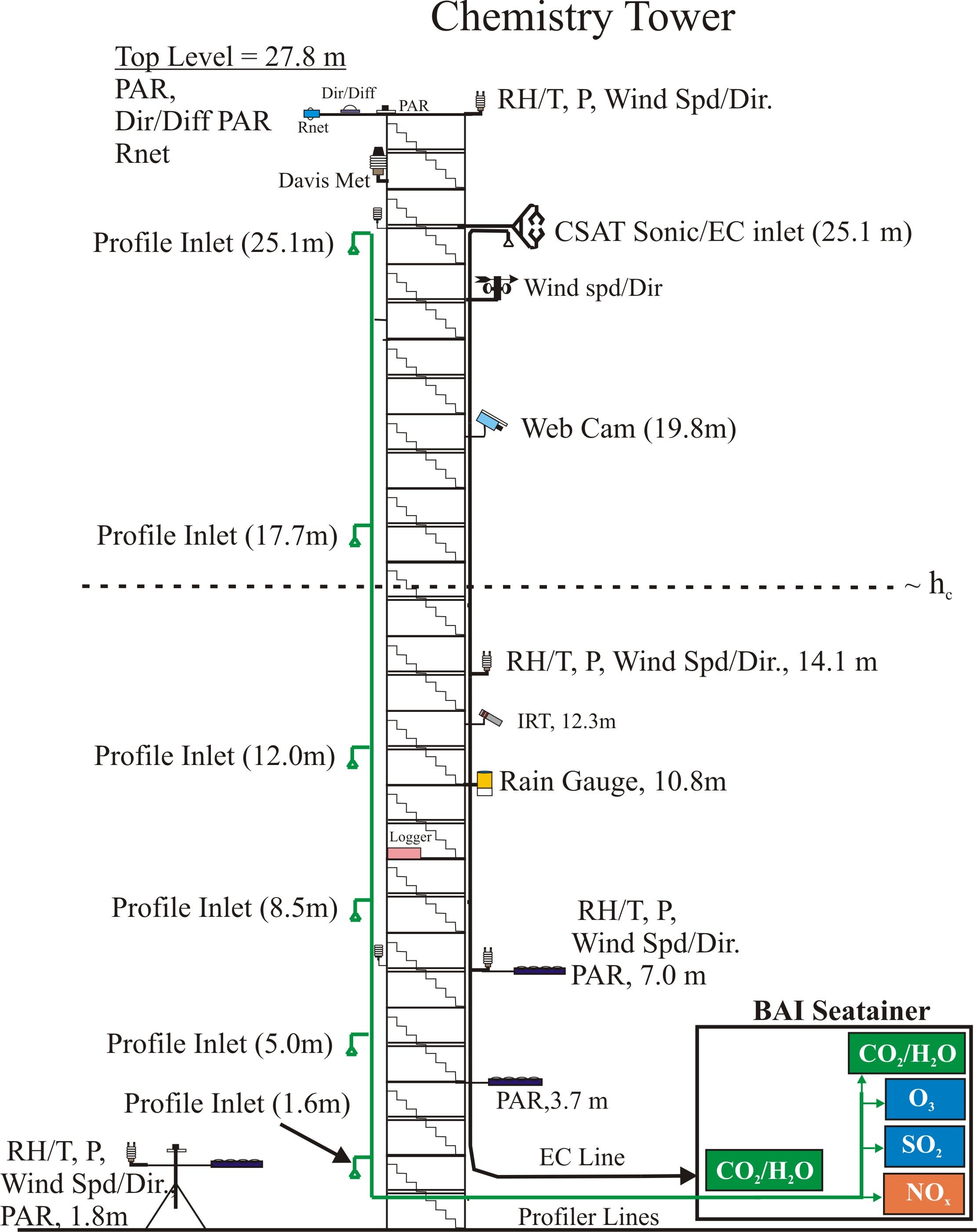
Chemistry tower: Walk up type: height, 28m height. Suitable for eddy covariance, gradient measurements, profiles. Four (4) Mobile Laboratories with 160 ft2 (14.9 m2) space, numerous sampling ports, temperature-control and 20 kW power.
Chemistry Tower Configuration
MANITOU: Tower
NCAR/ACOM
Site Description
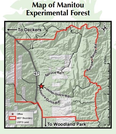
Manitou Experimental Forest Detailed Map by US Forest Service
US Forest Service
This forest’s elevation ranges from 2280 to 2840m ASL, and vegetation is primarily composed of forests of ponderosa pine, Douglas fir, mixed conifer and aspen. Soils underlying the tower site and the surrounding area are classified as deep, well-drained sandy loams and sandy gravelly loams originating from alluvial deposits weathered from underlying arkosic sandstone formations as well as nearby granite formations (Soil Conservation Service, 1992). The terrain slope is asymmetric across this valley with the east side of the valley being steeper and the west side being more gradual (gradient between 3 and 8%). The National Weather Service has been monitoring precipitation at MEFO since 1940 (Station Woodland Park 8 NNW, Coop ID: 059210), and US Forest Service staff have been collecting meteorological data including air and soil temperature, precipitation and wind speed since 1998.
Measurement Timeline
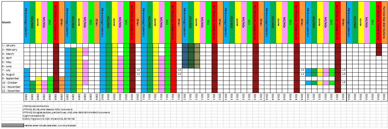
MANITOU: Project and Measurement Timeline
NCAR/ACOM
Principal Investigator
John Ortega UCAR
Data Manager
EOL Archive NCAR/EOL/DMS