A number of real time products will be available on the ground during research flight. These include the flight track and instrument data for GoogleEarth; a browser version of the instrument data; and data visualization using Aeros.
|
Data provided in real time should not be used in any publication as they are preliminary and will change after proper quality control. Even after formal data release these data should only be used with proper acknowledgment of the NSF and project researchers. |
Real-Time Flight Position in Google Earth
To use, open the file in Google Earth and check the desired checkbox. The flight tracking will be updated automatically once the flight takes off. Real time variables can be viewed by downloading current project KML file from the Field Project site and using the most common check boxes, or click on the folder name itself to display the full list of variables available, then select one from the list. Please note that the full list of variables is not updated automatically as we add new variables to the data feed, so re-load the KML file every few days to make sure you can see the new variables (if any). Adjust transparency of the overlays as desired. Real time satellite imagery can be enabled by selecting the appropriate checkbox.
Browser Data Access
Selecting variables from the list will display them as a strip chart. The charts will not refresh automatically, so use your browser's "Refresh" function to update the plots. Access data here. The list of variables displayed using this method is dynamic and is automatically updated every flight, so you will be able to see all variables transmitted to the ground during the current flight.
Aeros Software
Use right mouse click in the Aeros window after connecting the RT-GROUND database to add new graphs, variables etc. Download Aeros Software here. Aeros is the most flexible way of viewing the flight data in real time, it allows to zoom in, out, select time intervals to display; it will show data as time series, X-Y plots, 3D flight track and many other ways but is only available for Windows or Linux at this time. Aeros is built around mouse clicks: to start working with Aeros, right-click to add items, right-click on existing items to modify them, etc. We hope you will find Aeros intuitive and easy to use.
Real Time Digital Imagery
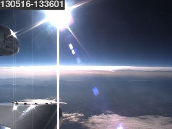 The NSF/NCAR aircraft are equipped with a forward looking digital camera. The imagery from this camera is used to reconstruct the conditions along the flight track, identify cloud entry times, cloud base altitude etc. We usually send reduced size images to the ground every few minutes and the latest image can be seen at the top of this page. They are also available as overlays in the Google Earth KML file that is used for real time flight tracking.
You can also see the approximate location of the flight on FlightAware. Please realize that FlightAware does not use any data feeds from the aircraft or NCAR and does not always provide an accurate real time position. Also, if the airplane is flying under Visual Flight Rules (VFR), the flight track will not be visible on FlightAware.
Relevant aircraft tail numbers: