VAMOS
Ocean-Cloud-Atmosphere-Land Study (VOCALS)
"Radiator fin"
(RF)
proposed field program.
Scientific
overview and
tentative plans
SCIENTIFIC
BACKGROUND
Interactions
between the South American continent and
the Southeast Pacific (SEP) Ocean are extremely important for both the
regional
and global climate system. The great height and length of the Andes
Cordillera
forms a sharp barrier to zonal flow, resulting in strong winds (coastal
jet)
parallel to the coasts of Chile and Peru. This, in turn, drives intense
oceanic
upwelling along these coasts, bringing cold, deep, nutrient/biota rich
waters
to the surface. As a result, the coastal SEP sea-surface temperatures
(SSTs)
are colder along the Chilean and Peruvian coasts than at any comparable
latitude elsewhere. The cold surface, in combination with warm, dry air
aloft
is ideal for the formation of marine stratocumulus clouds, and supports
the
largest and most persistent, yet poorly observed, subtropical
stratocumulus
deck in the world (Klein and Hartmann 1993).
Three
fundamental issues
impeding our understanding of the weather and climate system are (a)
our
current lack of understanding and quantification of the indirect effect
of
aerosols upon cloud radiative properties; (b) biases in tropical
rainfall, SST,
and winds that repeatedly occur in coupled ocean-atmosphere models,
which
several studies have traced in part to errors simulating ocean dynamics
in the
low-latitude coastal upwelling zones, and errors in simulating of
boundary
layer clouds and their radiative properties (e.g. Mechoso et al. 1995,
Ma et
al. 1996); (c) our inability to make consistently accurate regional
weather
predictions, especially in coastal areas dominated by low cloud.
VOCALS (VAMOS
Ocean-Cloud-Atmosphere-Land Study) is
an international program in which modeling, extended-time observations
(including a wealth of new satellite sensors, buoy, island and coastal
measurements), and intensive field observations (including annual buoy
maintenance cruises) in the SEP are coordinated to address these issues
over
the period 2003-2010. While extended-time observations are rapidly
improving
our understanding of this sparsely-traveled region, they have raised a
set of
interconnected scientific questions better addressed by an intensive
field
campaign.
The following
sections describe four key areas of
science that we hope to address with such a campaign which we propose
for a
four week period during October/November 2007. We call this the VOCALS
"radiator fin" (RF) experiment in recognition of the proposed cruise
track and
all Pierrehumbert's (1995) characterization of the subtropical
subsidence
regions as the Ôradiator fins' of the tropics in which the free
troposphere is
very dry and infrared radiation efficiently cools the earth system.
1.
Aerosol-cloud-drizzle interactions
Observations in
the SEP made during the EPIC 2001
field campaign (Bretherton et al. 2004) suggest that drizzle production
is
modulated by cloud droplet number concentration, which is directly
related to
aerosol concentration (e.g. Twomey and Warner 1967, Martin et al. 1994,
Breon
et al. 2002). Tantalizing evidence has been presented (Stevens et al.
2004)
suggesting a direct link between drizzle and cloudiness in MBL clouds
that is
manifest through regions of broken cloud organized into roughly
polygonal
lattices, called "open cellular convection", embedded within otherwise
overcast
stratocumulus. These regions have been termed POCs (Figure 1), or
"pockets of
open cells" (Stevens et al. 2004), and measurements suggest that POCs
tend to
be associated with low aerosol concentration (Petters et al. 2004), and
intense
drizzle production (Stevens et al. 2004). This link between drizzle
production
and cloudiness is central to the hypothesis of Albrecht (1989), namely
that
increases in anthropogenic aerosol may lead to a reduction in
precipitation and
a corresponding increase in global cloud cover and thickness. There
have been
attempts to test this hypothesis in GCMs (e.g. Lohmann and Feichter
1997, see
also review paper by Haywood and Boucher 2001), with sensitivities to
increases
in anthropogenic aerosol varying widely between models. This is hardly
surprising given (a) the huge quantitative differences in the
sensitivity of
the parameterizations of drizzle production to cloud microphysics (Wood
2004,
Pawlowska and Brenguier 2004); (b) the inadequate representation of the
turbulent structure and entrainment characteristics of cloud-topped
boundary
layers in GCMs (e.g. see Bretherton et al. 2004) which strongly
interacts with
their cloud (Bretherton and Wyant 1997) and precipitation (Nicholls
1987, Baker
1993) characteristics; (c) inadequate understanding of how to
parameterize
mechanisms modulating subgrid variability of cloud optical depth and
precipitation.
POCs are relevant to all three of these model uncertainties. There is a
strong
need for detailed observational studies of POCs, particularly studies
with
collocated aircraft in-situ measurements and
ground/shipborne remote sensing, to
determine whether POCs do indeed evince a fundamental mechanism whereby
aerosols can influence MBL cloudiness.
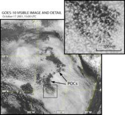
Figure
1: GOES Visible satellite image showing extensive stratocumulus cloud
cover
over the SEP, punctuated by pockets of open cells (POCs).
A two-month
"climatology" of the frequency of
occurrence of open cellular convection during September/October 2000
has been
constructed using a neural network method applied to MODIS data (Wood
and
Hartmann 2004). This clearly shows that open cells occur almost twice
as
frequently in the accessible regions (<1000 km from the coast) of
the SEP
than in the NEP (Figure 2). In addition to demonstrating the
climatological
significance of open cellular convection in regions dominated by marine
stratocumulus, it also highlights the suitability of the SEP as a
location for
a field program to examine POCs. During September/October 2000, open
cells were
present almost 40% of the time at the IMET Buoy (85W, 20S) and around
20% of
the time at San Felix Island (80W, 27S). However,
there are almost no direct observations of the
variability of aerosol or cloud droplet size distributions that we
think may be
associated with POCs. These observations are crucial to interpreting
satellite
observations that we do have, so that the link between aerosol
variability,
drizzle, and cloud organization can be convincingly made, and the role
of
anthropogenic vs. natural aerosol can be understood. In particular,
open cell
organization is also associated with largely non-precipitating shallow
clouds,
e.g. the climatological transition from stratocumulus to trade cumulus
cloud
regimes. These open cell convective clouds are usually seen further
offshore,
between 1500-2000 km from the coast in both the NEP and SEP, or in
midlatitude
cold air outbreaks. How much aerosol variability is affecting the cloud
fraction in either region is an important question, and one which we
currently
do not know how to answer with satellite observations alone.
NE Pacific
SE
Pacific
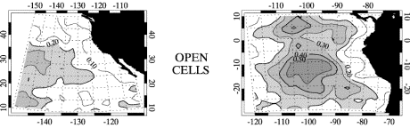
Figure
2: "Climatology" of the frequency of occurrence of open cellular
convection in
the NE Pacific (left) and SE Pacific (right) subtropical regions during
September/October 2000 (Wood and Hartmann, 2004).
2. Aerosol
production and variability
We believe POCs
are associated with spatiotemporal
patchiness in boundary layer aerosol, but our understanding of the
latter is
quite scant, especially in the SEP. Chemical transport models suggest
that there
are significant sources of both anthropogenic and natural aerosol that
can
influence the near-coastal SEP (Chin et al. 1996), with an extremely
strong
fall-off in anthropogenic influence westwards. Satellite retrievals of
the
cloud droplet effective radius over the SEP mirror these strong zonal
gradients
(Han et al. 1994, see also Fig. 3 below), with an increase in effective
radius
away from the coast. The optical thickness of a cloud is inversely
proportional
to its effective radius and increases linearly with liquid water path
(vertically
integrated liquid water content). Therefore, the causes of variability
in
effective radius and liquid water path need to be understood in order
to
accurately determine the radiative properties of clouds.
Variability in the
cloud effective radius is largely
controlled by variability in the aerosol concentration, size
distribution, and
chemical composition, which are generally thought to play a more
important role
in marine boundary layer clouds than variations in updraft speed and
thermodynamics. Aerosols that can act as nucleation sites for cloud
droplets
are termed cloud condensation nuclei (CCN) In the marine
boundary layer, the concentration of
CCN is strongly correlated with the concentration of aerosols with
diameters
larger than approximately 50 nm (often called the accumulation mode). Smaller
aerosols are too
small to efficiently act as CCN, and do not typically form cloud
droplets. The
effective radius tends to be large in a cloud growing in a low CCN
boundary
layer, because the available liquid water is shared among fewer
droplets. It is
therefore crucial to understand the sources and sinks of these
particles if we
are to understand the variability in cloud droplet sizes.
While CCN
concentrations range from <10 to >200
cm-3 in remote oceanic MBLs, the total aerosol concentration
(including the Aitken, accumulation, and coarse modes) is remarkably
stable (~300 cm-3).
This
implies that there must be a source of gas-to-particle conversion (GPC)
that
continually restores the population (Clarke et al. 1998). There is
considerable
debate about whether the major source is actually within in the MBL.
This stems
from the idea that the MBL typically has a large aerosol surface area
that
condensable vapors will favor over the energetic barrier of new
nucleation
(Covert et al. 1996). However, a number of observational studies do
show
compelling evidence indicating that nucleation of new particles can
occur in
the MBL (Clarke et al. 2002, Kollias et al. 2004, Petters et al. 2004),
especially when background aerosol concentrations have been lowered by
precipitation. Indeed, the Kollias et al. study used data from the PACS
2003
cruise in the SE Pacific (part of VOCALS), indicating that this region
is prone
to nucleation events. Coastal regions are particularly prone to
nucleation
events (O'Dowd et al. 2002).
New nucleation
results in very small particles that
require several days to grow and coagulate to a size sufficient to be
effective
CCN (Hoell et al. 2000). Processes by which these particles are
produced and
lost through precipitation scavenging require investigation, though
this is
also being studied in other ongoing projects in the NEP.
Models of new
nucleation generally do not favor new
particle formation in the MBL (Raes et al. 1995, Clarke et al. 1998),
but these
have attempted to simulate only the GPC of sulphuric acid produced via
the
oxidation of dimethylsulfide (DMS) which is considered to be the main
oceanic
aerosol precursor species (Charlson et al. 1987). Mass spectrometry of
recently
nucleated particles in the MBL show large fractions of
iodine-containing
species (O'Dowd et al. 2002) that have been shown in smog-chambers to
successfully nucleate even at high relative humidities that are
unfavorable for
sulphuric acid GPC. Iodine production over the coastal zone is related
to
algae, but this source alone is insufficient to account for the
observed
concentrations of certain iodine species over the open ocean.
Recent inventories
of sulfur production from ships
(Capaldo et al. 1999) suggest that even over the remote ocean, a
significant
fraction of the sulfate aerosol production can be anthropogenically
produced.
In the NE Atlantic and Pacific where several field programs to
investigate
aerosol-cloud interactions have been conducted (e.g. ASTEX, Albrecht et
al.
1995; ACE-2, Johnson et al. 2000; DYCOMS-II, Stevens et al. 2003),
estimates
suggest that 50-80% of the atmospheric sulfur dioxide is ship-produced
(Capaldo
et al. 1999). Although subsequent research (Davis et al. 2001) has cast
some
doubt on the quantitative aspects of the Capaldo et al. findings, it
seems
likely that only in the remote regions of the Southern Hemisphere, such
as the
SEP, that a truly unpolluted aerosol environment can be found which
provides an
analogue to pre-industrial conditions over the oceans of the Northern
Hemisphere.
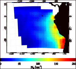
Figure
3: Estimated median cloud droplet concentration Nd from
MODIS data (Sept/Oct
2000). Estimates are deduced from cloud top effective radius and
optical depth
retrievals (King et al. 1997) using transformation to Nd of
Szczodrak
et al. (2001).
3. Ocean
heat transport
The Peru current
drives one of the strongest and most
extensive regions of coastal upwelling which strongly depresses coastal
SSTs. Instead
of a uniform upwelling along the coast, with a surface offshore Ekman
flow and
a deeper return flow, it is now understood that much of the transport
is
turbulent and time-varying, with mesoscale eddies, Rossby, and
coastally-trapped Kelvin waves playing an important role as in the NE
Pacific
(e.g. Kelly et al. 1998). The complexity of the processes involved in
transporting heat from the coastal upwelling regions to regions further
offshore has hindered a complete understanding the role of coastal
upwelling in
determining the climatological distribution of SST and its subseasonal
variability over the SEP. It is also unclear whether other processes
such as
coastal wave-trapping are also of importance. Deployment of an IMET
Buoy at
85W, 20S is in part motivated by the need to understand these ocean
heat and
momentum transport processes in the SEP, a region that has been much
less
intensively studied than the NE Pacific. However, the scope of a single
measurement location is limited, especially as the processes involved
are
varying strongly in time and space.
A spatial survey of the vertical structure of the oceanic wave
and eddy
field in this region, e.g. via towed SeaSoars (Pollard 1986) or other
underwater
gliders, would provide a rich context for understanding the buoy time
series
and altimetry data, as a well as a comparison with coupled and regional
ocean
model simulations.
4. Diurnal
cycle
Clouds over the
SEP exhibit a much stronger diurnal
cycle of cloud cover (Rozendaal et al. 1995) and cloud liquid water
path (Wood
et al. 2002) than the MBL clouds at comparable latitudes in the
northern
hemisphere. Regional model simulations (Garreaud and Mu–oz, 2004)
suggest that
a large-scale subsidence wave formed by the interaction of the coastal
jet
along the Chilean coast with dry convective heating over the western
Andean
slopes can travel at least 1000 km over the SEP and lead to a strong
diurnal
cycle of subsidence. The phase of the wave may be such that it can
strengthen
the existing diurnal cycle of MBL depth and cloud liquid water path.
Recent
satellite measurements of surface divergence from Seawinds (Robert
Wood,
personal communication) suggest that the peak-to-peak amplitude of the
divergence over much of the SEP can be 40-60% of the mean, with reduced
subsidence during the night over the region of climatological maximum
low cloud
cover (Bretherton et al. 2004). This has a rectified effect on the
clouds and
their radiative properties because it allows the MBL depth to deepen
more
rapidly at night resulting in thicker, more water laden clouds
(Garreaud and
Mu–oz, 2004) compared with MBLs without the diurnal cycle of
subsidence. These
clouds are more prone to early-morning drizzle, and are then followed
by rapid
thinning aided by the increased daytime subsidence that reduces the
efficiency with
which the clouds can reflect sunlight back to space.
Further modeling
work must be carried out to examine
its vertical structure, phase speed, seasonal cycle and climatological
significance. However, it is also important to observationally test
these model
predictions. Although the satellite divergence measurements provide one
means
to examine the diurnal cycle over the SEP, radiosonde measurements of
the
thermodynamic structure of the lower free-troposphere in the SEP will
be
invaluable in providing information concerning the wave's depth and
phase speed
that can be compared to mesoscale model simulations like those of
Garreaud and
Mu–oz (2004).
Specific
questions to be addressed during
VOCALS-RF
- What factors
influence the formation of drizzle in the remote and coastal SEP?
- What are the
physical processes responsible for generating pockets of open cells
(POCs) within otherwise overcast stratocumulus cloud regimes? Does a
POC cause aerosol depletion through scavenging, or is depleted aerosol
a POC precursor?
- What are the
aerosol characteristics in both the coastal and remote SEP region? How
do the contrasts affect cloud microphysics, and how are they related to
POCs? What are the major sources and sinks of aerosol over the SEP,
both natural and anthropogenic?
- What are the major
transport processes for coastally upwelled water to regions further
offshore? Do mesoscale eddies play a dominant role? With current
coupled ocean+atmospheric models at sufficient horizontal resolution,
can the mean SST distribution in the SEP be successfully reproduced?
- Do the depth,
phase speed, and vertical structure, of the diurnal subsidence wave ("upsidence wave") originating in northern
Chile/southern Peru agree with Garreaud and Muñoz simulations?
- Are current numerical models able to accurately simulate the synoptic variability in cloud cover and albedo in the SEP on daily timescales? If not, can we deduce whether model initialization data, boundary layer physics, or aerosol-cloud microphysics is chiefly to responsible?
Logistics of
planned VOCALS 2007 field program
An effective study
of the processes above cannot
possibly be achieved with a single measurement platform, and so we will
combine
the capabilities of a ship, at least one instrumented aircraft, and
ground
based in-situ and remote sensing measurements at San Felix Island. Such
a
combination of observations has not been assembled in the NEP despite
many
coastally-focused stratocumulus studies off the Californian coast that
rely
mainly upon aircraft observations. The long, well-calibrated IMET buoy
record
has no counterpart in the NEP stratocumulus regime, nor is there an
island in
the NEP that is both well offshore but still in the stratocumulus
region. Table
1 summarizes the chief measurement platforms, their coverage and the
broad
scientific goals to be addressed.
VOCALS 2007
Study Region
The VOCALS study
region is shown in Fig. A1, and
comprises that part of the SEP east of 90W and between 15S and 30S. All
field
campaign operations will be conducted within the study region. San
Felix Island
is at 80W, 27S. The IMET Buoy is at 85W, 20S. These locations will form
the NW
and SE extrema of a "radiator fin" pattern (Fig. A1) to be carried
out over a four week period by the NOAA R/V Ronald H Brown. This pattern is
designed to maximize the sampling of ocean currents and ocean surface
properties, particularly its mesoscale variability, in the region
between the
S. American coast and the remote SEP to the west of the Peru current. A
schematic cross section from coastal northern Chile to the IMET Buoy is
given
in Fig A2.
Table 1:
Measurement
platforms, their coverage, and main science goals
|
Measurement
Platform |
Coverage/sampling |
Main science
goals |
|
NOAA R/V Ronald H Brown (ship) |
"Radiator fin"
pattern originating close to the S American coast and moving to the WSW
over a period of 4 weeks (Fig A1) |
•
Cloud-aerosol-drizzle
interactions •
MBL structural
properties and energy/moisure budgets •
Ocean heat
transport, SST and ocean current mapping •
Diurnal cycle of
MBL and free-troposphere |
|
NSF NCAR C-130 (aircraft) |
(a)
Lagrangian-type flights to follow and map out POCs and surrounding
stratocumulus (Fig A3) (b) Cross
sectional flights between Arica (Chile) and either the IMET Buoy or San
Felix Island (Figs A1 and A4) |
•
Cloud-aerosol-drizzle
interactions •
Aerosol
characterization, sources/nucleation •
MBL and cloud
structure between the S American coast and the remote SEP |
|
IMET Buoy (85°W,
20°S) |
Fixed location,
surface sampling of MBL properties, radiation, SST, ocean currents (Fig
A1) |
•
Daily to
interannual variability of SST, cloud and MBL properties. •
Ocean heat
transport |
|
San Felix Island (80°W,
27°S) |
Fixed location
sampling of aerosol, cloud, and drizzle properties. Possible deployment
of the ARM Mobile Facility (AMF) for period around field program. |
•
Cloud-aerosol-drizzle
interactions •
POCs structure and
initiation •
Aerosol
sources/sinks in the remote SEP |
|
Coastal Chile/Peru |
TBD |
•
Coastal
meteorology and cloud cover |
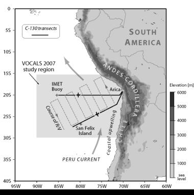
Figure
A1: Map of the southeast Pacific (SEP), and South American orography.
The
VOCALS 2007 study region comprises the region between latitudes 15S and
30S,
and all ocean east of 90W. The proposed track of the Ronald H Brown is shown, along with the locations of
the IMET Buoy, San Felix Island, and the flight tracks for the
cross-section
flights with the NCAR C-130.
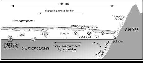
Figure A2:
Schematic showing an E-W cross section
from the IMET Buoy (85W, 20S) to the S. American coast, detailing the
lower
atmospheric and upper oceanic structure and some important processes.
Aircraft
flight plans (tentative)
The
NCAR C-130 will be the primary aircraft involved in VOCALS 2007. There
is some
possibility that other aircraft will participate in the field phase
(e.g. The
Met Office BAe-146), but these are not crucial to the success of the
program.
Two flight plans (Table 1) have been proposed for C-130 activities:
(a)
Cross-section
missions (Fig A3: These flights are designed to examine contrasts
between the
MBL and lower atmosphere close to the S. American coast and that in the
remote
SEP. Specific focus will be placed on examination of aerosol
characteristics,
MBL structure/depth, cloud morphology, microphysics, and drizzle
production
(using the University of Wyoming 94 GHz cloud radar, WCR, on the
C-130). Other
interests include cloud remote sensing, and there will be efforts made
to
coordinate some of these missions with satellite overpasses,
particularly those
of Terra and Aqua/A-train at roughly 10:30 am/pm and 1:30 am/pm local
time. The
essential idea is to fly along the 20S parallel out from the coast to
the IMET
Buoy. On the way out, the flight will comprise a set of straight and
level runs
below (30 m AMSL daytime, 150 m AMSL nighttime) and above (1800 m AMSL)
cloud,
and to sample the cloud layer itself using slant profiles ascending at
some 150
m/minute. The precise set of runs used will be dependent upon the needs
of the
key participants. The above cloud runs will be used to sample the
drizzle
structure using the MMCR, to characterize the free-tropospheric aerosol
and
thermodynamic structure, and to use the shortwave imaging radiometer to
remotely sense the cloud bulk and microphysical properties. Below cloud
runs
will aim to determine physicochemical properties of aerosols, and to
determine
the lower boundary conditions (SST, surface fluxes, winds). The return
leg back
from the IMET buoy will be carried out at approximately 6km with
dropsondes
being launched at regular intervals. Because drizzle is expected to be
more
prevalent during the night, flights will be flown both in the day and
at night.
This type of flight plan was implemented very successfully during EPIC
2001 for
studying southerly cross-equatorial boundary layer inflow into the East
Pacific
ITCZ (e.g. Raymond et al. 2004, deSzoeke and Bretherton 2004).
(b)
POC missions (Fig
A4: These
flights are designed specifically to examine microphysical and
dynamical
processes occuring both in pockets of open cells (POCs) and in the
surrounding
cloud. POCs that are completely surrounded by overcast stratocumulus
clouds are
of the most interest, but boundaries between open and closed cellular
convection will also be a focus of these missions. Of particular
importance
will be a characterization of the aerosol and cloud microphysics in the
two
regions. If possible, these flights will be coordinated with the ship
which
will be able to provide a scanning radar capability (C-band on the
Ronald H
Brown) as well as aerosol and cloud characterization. The idea is to
use geostationary
satellite imagery to locate POCs, and then to target missions
accordingly. Once
a POC boundary has been reached, the aim is to carry out across-wind
stacks of
five straight and level runs below, in, and above cloud (with
additional
porpoising runs to characterize the cloud top and inversion layers).
The
aircraft will be allowed to drift with the MBL mean wind (i.e. with the
advecting POC).
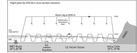
Figure
A3: Flight plan for C-130 cross-sectional missions. The flight will
consist of
a set of slant profiles and straight and level runs from the coast out
to
either the IMET Buoy, or to San Felix Island. Runs above cloud will be
used to
remotely sense the cloud and drizzle structure. Profiles will be used
for
in-situ characterization of the cloud and drizzle. On the return leg at
approximately 6 km altitude, a series of dropsondes will be launched to
map out
the vertical structure of the MBL and lower free troposphere across the
region.
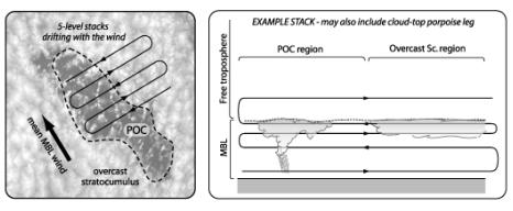
Figure
A4: Lagrangian-type C-130 flight plan to sample POCs and surrounding
overcast
stratocumulus. Flight will consist of 4-6 crosswind stacks drifting
with the
mean MBL wind (left). Each stack will consist of straight and level
runs close
to the surface, below mean cloud base, just above cloud base, below
cloud top,
and above cloud. Each run will be approximately 120 km in length, with
roughly
equal fractions inside and outside of the POC region.
References
Baker, M. B.,
1993:
Variability in concentrations of cloud condensation nuclei in the
marine
cloud-topped boundary layer. Tellus, 45B, 458-472.
Breon, F. M., D.
Tanre, and
S. Generoso, 2002: Aerosol effect on cloud droplet size monitored from
satellite. Science,
295,
834-838.
Bretherton, C.S,
and M.C.
Wyant, 1997: Moisture transport, lower tropospheric stability and de
coupling
of cloud-topped boundary layers. J. Atmos. Sci., 54, 148-167.
Charlson, R. J.,
J. E.
Lovelock, M. O. Andreae, and S. G. Warren, 1987: Oceanic phytoplankton,
atmospheric sulphur, cloud albedo and climate. Nature, 326, 655-661.
Chin, M., D. J.
Jacob, G. M.
Gardner, P. A. Spiro, M. Foreman-Fowler and D. L. Savoie, 1996: A
global
three-dimensional model of tropospheric sulfate, J. Geophys. Res., 101, 18,667-18,690.
Clarke A. D., D.
Davis, V. N.
Kapustin, F. Eisele, G. Chen, I. Paluch, D. Lenschow, A. R. Bandy, D.
Thornton,
K. Moore, L. Mauldin, D. Tanner, M. Litchy, M. A. Carroll, J. Collins,
C.
Albercook, 1998: Particle nucleation in the tropical boundary layer and
its
coupling to marine sulfur sources, Science, 282, 89-92.
Covert, D. S., V.
N.
Kapustin, T. S. Bates, and P. K. Quinn, 1996: Physical properties of
marine
boundary layer aerosol particles of the mid-Pacific in relation to
sources and
meteorological transport. J. Geophys. Res., 101 , 6919-6930.
Davis, D. D., G.
Grodinsky,
P. Kasibhatla, J. Crawford, G. Chen, S. Liu, A. Bandy, D. Thornton, H.
Guan,
and S. Sandholm, 2001: Impact of emissions on marine boundary layer NOx
and SO2 distributions over the Pacific basin, Geophys.
Res.
Lett., 28, 235-238.
Han, Q, W. B.
Rossow, and A.
A. Lacis, 1994: Near-global survey of effective droplet radii in liquid
water clouds
using ISCCP Data. J. Clim., 7, 465-497.
Hoell, C., C.
O'Dowd, S. R.
Osborne, D. Johnson, 2000: Time-scale analysis of marine boundary layer
aerosol
evolution: Lagrangian case studies under clean and polluted cloudy
conditions, Tellus,
52B, 423-438.
Kelly, K. A., R.
C.
Beardsley, R. Limeburner, K. H. Brink, J. Paduan, and T. K. Chereskin,
1998:
Variability of the near-surface eddy kinetic energy in the California
Current
based on altimetric, drifter, and moored current data. J. Geophys.
Res.,
103, 13067-13083.
Lohmann, U. and J.
Feichter,
1997: Impact of sulfate aerosols on albedo and lifetime of clouds: A
sensitivity study with the ECHAM4 GCM. J. Geophys. Res., 102, 13685-13700.
Ma, C.-C., C. R.
Mechoso, A.
W. Robertson and A. Arakawa, 1996: Peruvian stratus clouds and the
tropical
Pacific circulation - a coupled ocean-atmosphere GCM study. J. Clim., 9, 1635-1645.
Pollard, R., 1986:
Frontal
surveys with a towed profiling conductivity temperature depth
measurement
package (SeaSoar), Nature, 323, 433-435.
Mechoso, C. R., A.
W.
Robertson, N. Barth, M. K. Davey, P. Delecluse, P. R. Gent, S. Ineson,
B.
Kirtman, M. Latif, H. Le Treut, T. Nagai, J. D. Neelin, S. G. H.
Philander, J.
Polcher, P. S. Schopf, T. Stockdale, M. J. Suarez, L. Terray, O. Thual
and J.
J. Tribbia, 1995: The seasonal cycle over the Tropical Pacific in
general
circulation models. Mon. Wea. Rev., 123, 2825-2838.
Nicholls, S.,
1987: A model
of drizzle growth in warm, turbulent, stratiform clouds. Quart. J.
Roy.
Meteorol. Soc.,
113,
1141-1170.
O'Dowd C.D. , J.
L. Jimenez,
R. Bahreini, R. C. Flagan, J. H. Seinfeld, K. Hameri, L. Pirjola, M.
Kulmala, S.
G. Jennings, and T. Hoffmann, 2002: Marine aerosol formation from
biogenic
iodine emissions, Nature, 417, 632-636.
Pierrehumbert, R.
T. 1995:
Thermostats, Radiator Fins, and the Local Runaway Greenhouse. J.
Atmos. Sci. 52, 1784-1806.
Raes, F., 1995:
Entrainment
of free tropospheric aerosols as a regulating mechanism for cloud
condensation
nuclei in the remote marine boundary layer. J. Geophys. Res., 100, 2893-2903.
Raymond, D. J., S.
K.
Esbensen, M. Gregg, and C. S. Bretherton, 2004: EPIC2001 and the
coupled
ocean-atmosphere system of the tropical east Pacific. Bull. Am.
Meteor.
Soc., in
press.
Szczodrak, M., P.
H. Austin,
and P. B. Krummel, 2001: Variability of optical depth and effective
radius in
marine stratocumulus clouds. J. Atmos. Sci., 58, 2912-2926.
de Szoeke, S.P.
and C.S.
Bretherton, 2004: Quasi-Lagrangian large eddy simulations of
cross-equatorial
flow in the east Pacific atmospheric boundary layer.
J. Atmos. Sci., 61, 1837-1858.