CRUISE SCIENCE REPORT
WINTER SBI AIRCRAFT
SAMPLING
1 - 15 April 2003
By:
P.I.: John P. Christensen Bigelow Laboratory
180
McKown Point
W.
Boothbay Harbor ME 04575
207-633-9600
jchristensen
@ bigelow.org
Co.P.I. Humfrey Melling Institute of Ocean Sciences
P.O.
Box 6000
Sidney BC
V8L 4B2 Canada
250-363-6552
mellingh
@ dfo-mpo.cg.ca
SAMPLING. Winter sampling was performed in the eastern
area of the Shelf-Basin Interactions Project using aircraft. Flights began on 1 April 2003 and finished
on 15 April. During this time, we were
able to sample 42 sites (49 CTD casts) on a series of 5 transect lines which
bracketed and were parallel to the SBI current meter mooring line located at
152oW longitude. Stations
were about 10 km apart along each transect line. Transect lines B, C, and D were at the same spacing; while, lines
A and E were 20 km from the nearest transect line. The achieved sampling covered an area about 50 km across the
slope and 80 km along it and represents a truly 3-dimensional view (Fig.
1). Typically, 4-5 stations were
sampled on each flying day. At each
site, a Seabird CTD and Satlantic ISUS nitrate analyzer with a water sampling
bottle were deployed through an 8 inch hole augured in the pack-ice. Continuous profiles of pressure,
temperature, salinity, nitrate and bromide concentrations were made from the
ice hole to either the sediment surface or to about 390 m. Water samples (1.2 L total volume) were
collected at key depths, as evaluated by the on-deck instrument readout. Typically 5-8 water samples were taken on
most casts. Water was subdivided for
samples of inorganic nutrients, organic N and P, bromide concentrations,
salinity determinations, and O-18 isotopic content of the water.
The ISUS nitrate analyzer measures
nitrate concentrations optically at relatively high sampling rates (about 1
replicated measurement every 3 seconds).
As this is the first commercial instrument of its kind, we noticed
variations possibly due to instrument drift (notice the possible scatter in
individual nitrate readings in Fig. 2).
Also, we cannot at this time guarantee that the manufacturer's
algorithms yield accurate nitrate concentrations; our own calibration will be
conducted in the upcoming months and results will be correlated with
autoanalyzer measurements.
RESULTS: CTD and ISUS data are currently being processed and water samples
await analysis. However, the
unprocessed results showed several important things. Near the shelf break, intense mixing of shelf waters with slope
waters were apparent by the occurrence of interleaving layers of waters of
different temperature, salinity, and nitrate concentrations (Fig. 2). The number of these interleaving layers and
their water properties differed between the 5 transect lines suggesting that
this mixing is associated with the mesoscale field in this area. Secondly, in all transects, the data showed
a slope boundary current centered at or near 150 m depth (Fig. 3c). This current seemed to be associated with
some of the highest nitrate concentrations seen in the area; although in this
section, the maximum concentrations were found near the bottom of the current
(Fig. 3c,d). This association suggests
this current may be extremely important in transporting and redistributing
nutrients in the shelf-slope area.
Thirdly, in transect line C, a small eddy-like structure was seen. Adjacent transects (i.e. line D, Fig. 3)
showed little evidence of this small eddy.
From our sampling, its size would be about or less than 20 km in
diameter and it did not seem connected to the slope current through meanders or
other swirl-like distributions. A
similar small eddy was found in nearly the same location during the summer SBI
mooring cruise. Water properties of our
eddy seemed to differ from shelf waters or the waters within the slope
current. Fourth, Atlantic water was
found below about 200 m in all the deeper sites and distributions suggested
upwelling along the slope and possible variations in depth across the sampled
transects. Graphs of temperature versus
salinity from our cruise (Fig. 4) show the range in variability of the water
masses relative to reference curves from sampling in the same area in 1981 and
2001. The general freshening and the
slight warming of the Fram Strait Branch of the Atlantic water in this region
over the last two decades is clear.
These trends have accelerated noticeably since 1996 (viz. Melling JGR
103, C4, 7637-7645). Water warmer than
0.7oC at this longitude has appeared only during the last year. The recent change may indicate the arrival
of the signal (much attenuated) that entered the Arctic through the Fram Strait
more than a decade ago.
Overall, the entire data ensemble
demonstrates the startling magnitude of variability in T-S correlation over the
small (mesoscale) domain of our survey.
Near the peak in temperature, the variation over the study area
encompasses the full range of change during the past twenty years. Our three-dimensional survey resolves important
scales of baroclinic and topographic change, but also encourages future caution
in interpreting data acquired during broad surveys over the continental slope
in the Arctic.
UPCOMING: Over the next months, we will finalize the
electronic data and analyze the returned water samples. The resulting data will be posted in the SBI
data repository. We expect to have a
strong set of data regarding the late-winter nutrient conditions in the outer
shelf and slope of this area; this will be useful in predicting spring algal
bloom intensities. We will be looking
at the influence of the mesoscale physical field in determining nutrient
properties. Our data, coupled with the
results from the current meter mooring line, should allow estimates of the
temporal and spatial variation in the shelf break region. By examining the details of the water
properties, it may be possible to evaluate possible water sources.
file: srpt3fec.doc submission
date: 16 June 2003
|
|
|
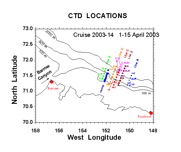
Figure 1. Map of
sampling locations on cruise 2003-14.
CTD cast numbers identify each site.
|
|
|
|
|
|
|
|
|
|
|
|
|
|
|
|
|
|
|
|
|
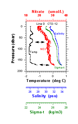
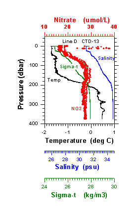
Figure 2. Vertical profiles of temperature, salinity,
density (sigma-t), and ISUS nitrate concentrations at CTD # 12 (left) and 13
(right). The two stations are about 10
km apart on transect Line D.
Interleaving layers of different temperature and nitrate content
dominate the profiles at CTD 12 but appear lacking in the upper waters at CTD
13.
|
|
|
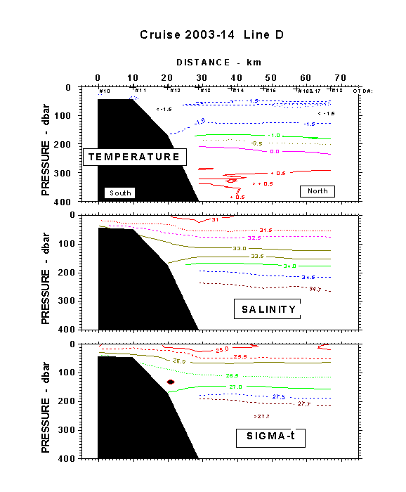
Figure 3. Sections
of temperature in degrees (A top), salinity in practical salinity units (B
middle), and density in kg/m-3 (C bottom) along transect line D on cruise 2003-14, 1-15
April 2003. The darkened oval
represents the likely core of upper slope current, flow toward the reader.
|
|
|
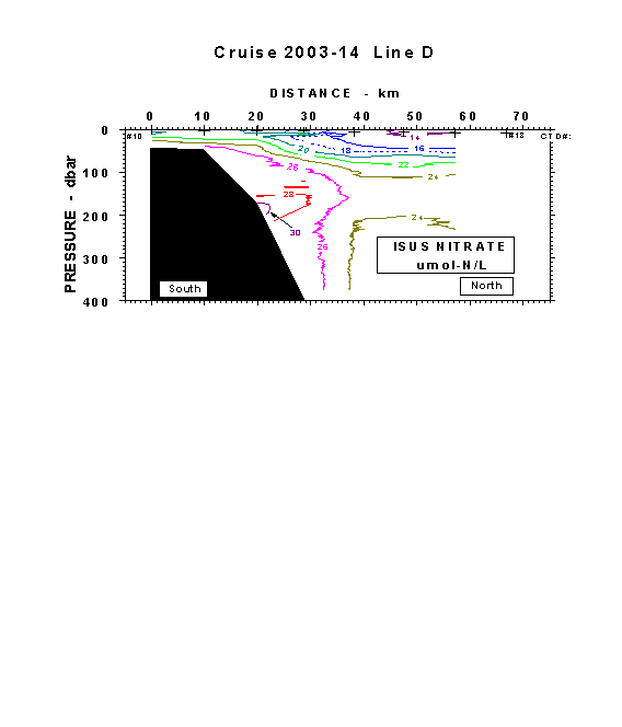
Figure
3D. Section of nitrate concentration in
micromoles/l based on raw ISUS profiles from Line D of cruise 2003-14.
|
|
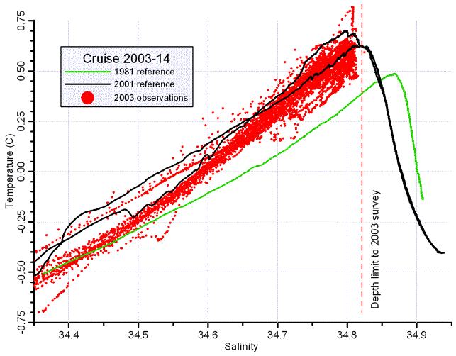
Figure 4. Temperature-salinity relationships from all
data during cruise 2003-14 off the Beaufort continental shelf in April 1-15
2003. Reference lines represent
samplings taken during 1981 and 2001.
The peak temperature is the signature of the core of the Atlantic water
entering from Fram Strait as found in the southern Beaufort Sea. Note that the Atlantic water core has warmed
and become less salty over the last 20 years.