
This table summarizes some basic characteristics of models providing MOLTS output for CEOP. DRAFT
| Center (Linked to further documentation) |
Model Name and Type (operational, re-analysis, forecast, ...) |
Model Horizontal Resolution (Both spectral and long/lat or km information) |
Time Resolution | Number of Vertical Levels | Vegetation Description Scheme Used (name and number of types, details in a separate table) |
Soil Description Scheme Used (name and number of types, details in a separate table) |
MOLTS Location Characteristics Table | MOLTS Format | Citation |
| BMRC | Operational Global Medium Range Prediction Model | T239L29 | 1 hour | 29 | bucket hydrology | 3 layers | netCDF | Citation | |
| CPTEC | CPTEC/COLA | T126 gaussian grid ~1.125 degrees on pressure surfaces |
6 hours | 28 | SSiB scheme 13 vegetation types |
13 types related to the vegetation | IEEE binary read from GRADS |
Citation | |
| ECMWF | ERA-40 (and continuation) | T159 Reduced gaussian grid (125 km) | 1 hour | 60 | TESSEL BATS classification |
1 soil type | Table ERA-40 | ASCII | |
| Operations | T511 Reduced gaussian grid (39 km) | 1 hour | 60 | TESSEL BATS classification |
1 soil type | Table Operations | ASCII | ||
| ECPC | Reanalysis-II | T62L28 2.5 X 2.5 degrees on pressure surfaces ~1.875 X 1.9 gaussian grid on sigma surfaces |
3 hours | 28 sigma 17 pressure |
12 vegetation types | OSU2 LSM 2 soil levels fixed soil type as either glacial or sandy clay loam |
Table | NetCDF | Citation |
| Seasonal Forecast Model | T62L28 2.5 X 2.5 degrees on pressure surfaces |
3 hours | 28 sigma 17 pressure |
USGS Monthly 12 vegetation types | OSU2 LSM 2 soil levels 16 soil types | Table | NetCDF | Citation | |
| GLDAS | Mosaic Land Surface Model | 0.25 x 0.25 degree | 3 hours | 3 soil layers | UMD 14 land cover types | Reynolds et al (2000)
global 5 min resolution data set
Soil Parameter Illustrations NLDAS soil classes |
Locations | ASCII | |
| Noah Land Surface Model | 1 x 1 degree | 3 hours | 4 soil layers | UMD 14 land cover types | Reynolds et al (2000)
global 5 min resolution data set
Soil Parameter Illustrations NLDAS soil classes |
Locations | ASCII | ||
| GMAO | GEOS3 (available now) |
1x1 degrees | 3 hourly sfc, 6 hourly 3d atm | 27 | Mosaic LSM | 3-layers | Locations and Veg Type | ||
| GEOS3-TRMM (available soon) |
1x1 degrees | 3 hourly sfc, 6 hourly 3d atm | 27 | Mosaic LSM | 3-layers | Locations and Veg Type | |||
| GEOS4 (available soon) |
1x1.25 degrees | 3 hourly sfc, 6 hourly 3d atm | 36 | NCAR CLM | 10-layers | ||||
| JMA Phase 1 | JMA-GSM for operational global data assimilation system (3D-Var) Grid M1 |
T213L40 MOLTS 1.25 X 1.25 degrees (fundamental variables) |
1 hour | 23 pressure | Simple Biospehere scheme (SiB) 13 vegetation types |
13 types (coincident with vegetation types) | Locations Properties |
ASCII | Citation |
| JMA-GSM for operational global data assimilation system (3D-Var) Grid M2 |
T213L40 640 X 320 grids (radiation budget, surface processes) |
1 hour | TOA and surface | Simple Biospehere scheme (SiB) 13 vegetation types |
13 types (coincident with vegetation types) | Locations Properties |
ASCII | ||
| JMA-GSM for operational global data assimilation system (3D-Var) Grid M3 |
T213L40 320 X 160 (heating rate) |
1 hour | 40 model eta coordinates | Simple Biospehere scheme (SiB) 13 vegetation types |
13 types (coincident with vegetation types) | Locations Properties |
ASCII | ||
| JMA Phase 2 | JMA-GSM for operational global forecast | T959L60 Reduced Gaussian grid (20km) |
1 hour | 30 pressure | Simple Biospehere scheme (SiB) 13 vegetation types |
13 types (coincident with vegetation types) | Locations | netCDF | Citation |
| MSC | GEM (Global Environmental Multiscale model) Development version expected to be transfered to operations at the end of 2005. Used in forecast and assimilation modes. | 800x600 0.45 degree longitude 0.30 degree latitude |
900s timestep | 58 vertical levels | ISBA land surface scheme 22 types of vegetation specified from USGS 1-km global database |
ISBA land surface scheme 11 types of soil (STATSGO) in conterminous US and 3 types of soil in the rest of the world |
Locations and Characteristics | Citation | |
| NCEP | Global Forecast System | T254L64; T170L42 (prior to 29 Oct 2002); 768x384 grids (lon, lat) All variables |
3 hours | 64 pressure levels; 42 (prior to 29 Oct 2002) |
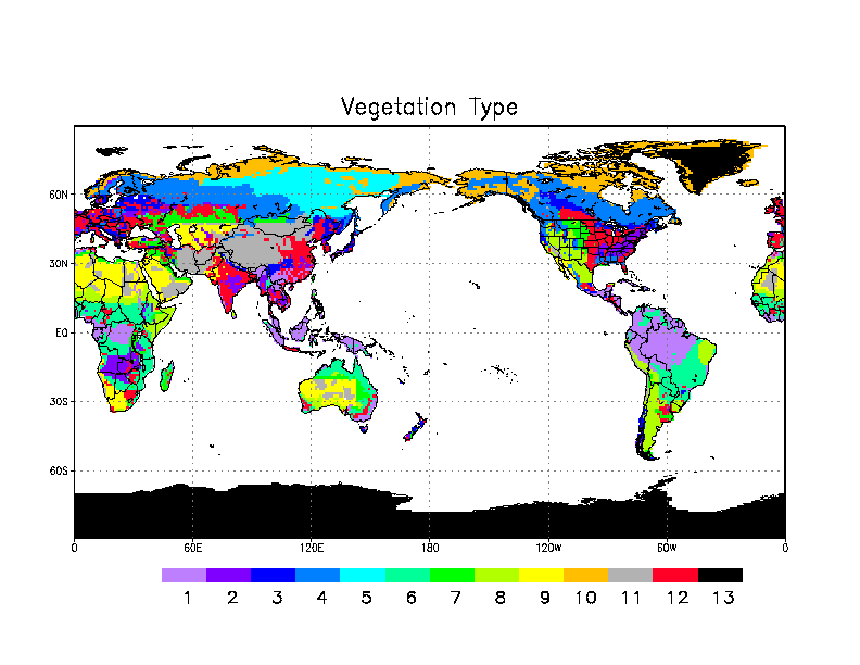
13 types (SIB) Map |
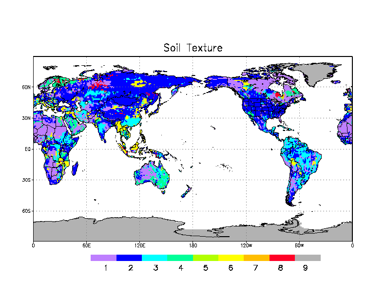
9 types (Zobler) Map |
Locations/Properties as of 1200 UTC, 31 May 2005 Locations/Properties for the period from 1200 UTC, 01 Dec 2002 through 0600 UTC, 31 May 2005 |
IEEE binary Reading Programs |
Citation |
| Global Reananlysis I | T62L28 (192 lon X 94 lat) | 3 hours | 28 pressure | IEEE binary Reading Programs |
|||||
| NCMRWF | T80L18 1.5 x 1.5 degrees |
Characteristics | |||||||
| UK Met Office | Global Unified Model | 0.83 x 0.56 degrees | 3 hours | 38 model levels; 19 diagnostic pressure levels |
MOSES Details Note |
MOSES Details Note |
Locatons | ASCII | Citation |