Form RAOBsites Documentation
MJ Mahoney
Last Revision: June 19, 2008
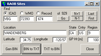
Figure 1. The RAOBsites form.
A list of radiosonde launch sites is saved in the C:\MTP\RAOB\BIN\MTP_UA.BIN file. As
discussed elsewhere, it has evolved from using data initially from a
list of WMO surface and upperair sites, to a list of GEMPAK sites, and
now finally to a list from the NOAA ESRL Gobal Systems Division
(formerly FSL) called intl2000.wmo. It
is
read from or written to using the RAOBsites
form.
The RAOBsites form can be
used to do several things:
1) Find information on a particular radiosonde launch site
The Find frame is used
to do just that. Data can be read by specifying the ICAO name, the WMO number or the Record number in the MTP_UA.BIN file; to do this select
the appropriate option. In Figure 1
the ICAO name for Vandenburg Air Force Base (VBG) was entered into the ICAO text box and the Go button depressed. This caused
the WMO, Record, Location, State,
Country, Region, Latitude, Longitude, and Geopotential Height text boxes to
be loaded with the relevant information from the MTP_UA.BIN file. (Currently the
Region text box shows the number 9 since the WMO region information is
not available in the intl2000.wmo
file. See below on how the MTP_UA.BIN
file is generated. The data structure used by this file is shown below.)
Depressing the N+1, N-1, Last
and First buttons read the
next, previous, last and first records respectively.
2) Update the MTP_UA.BIN file
The procedure now for updating the MTP_UA.BIN
file is as follows:
a) Go to the
NOAA
ESRL GSD Station History documentation and download the
intl2000.wmo
text file to the
C:/MTP/RAOB/BIN/
folder (or just right click on the last link and select the
Save Link As menu option). The
extension
.wmo simply means
that the file is ordered in sequence of increasing WMO station numbers.
(There is another file that is ordered in sequence of increasing WBAN
numbers, but these only apply in North America and so are less
general.) The intl2000.wmo has about 1900 entries, but it includes the
history for each North American station (that is, the period of time
the station was active at a particular location). When the
MTP_UA.BIN file is generated, only
active stations are included; there are 900-1000 active stations.
b) Run the CRLF.exe program to
add a carriage return to each line of the intl2000.wmo file.
c) Select the Export tab in
the RAOBman.exe program, and
then depress the Show RAOB Details
button near the bottom of the form bring up the RAOBsites form shown in Figure 1.
d) Finally, depress the Gen BIN button on the buttom left
of the
RAOBsites form to create a new version of the C:\MTP\RAOB\BIN\MTP_UA.BIN file.
This is the only RAOB file now read by MTP data analysis programs that
need radiosonde location information.
3) Write a MTP_UA.TXT file
In addition to the Gen BIN
button on the RAOBsites form,
there are two others: the BIN to TXT
and the TXT to BIN buttons.
The BIN to TXT button reads the MTP_UA.BIN file and writes it out as an
ascii text file named MTP_UA.TXT. This can be useful as a reference
list. It can also be editted in a text editor to add a new site or
remove an old site. If this is done, the TXT to BIN button can be used
to write a new version of the MTP_UA.BIN file. Before doing this,
always check to see if the intl2000.wmo has not already been updated.
If it hasn't, notify
NOAA ESRL GSD that they are not current.
Data Structure for Radiosonde Station
Location
  Type GPrecord
    GPcards As Long               ' CARDS number = WMO*10
    GPicao As String * 8          ' Alpha name
    GPlatitude As Single          ' Latitude
    GPlongitude As Single         ' Longitude
    GPaltitude As Integer         ' Geopotential Height (meters MSL)
    GPregion As Integer           ' WMO region
    GPcountry As String * 2       ' FIPS PUB 10-4 Country Code
    GPstate As String * 2         ' State
    GPstation As String * 32      ' Station name
    GPspare As Integer            ' Spare
  End Type