Steps In MTP Post-Campaign Data Analysis
MJ Mahoney
4. Download a radiosonde data base
Before radiosondes can be selected to calculate retrieval coefficients
(RCs), they need to be collected from somewhere. In the early days, we
collected sounding data in the raw TTY format that the NWS provided,
and then decoded them. Today there are many web sites that provide
decoded and quality-controlled soundings. In addition, I have
written
a program (RAOBget) to automate the download process. Basically, the
program is given a list of sondes sites, and a time interval over which
soundings are needed, and it takes care of the rest. To illustrate this
process, I will use the PAVE campaign, because it illustrates how
haphazard this process can be.
Before the PAVE campaign began, I knew that there would be test flights
out of Edwards AFB, and local science flights out Pease AFB in
Portsmouth, NH. It was expected that the 10 hour science flights would
go as far north as northern Greenland, and possibly as far south as the
equator. This would involve a LOT of work because of the broad range to
atmospheric conditions. To start off, I collected radiosondes
representing the conditions expected in California in January and
February from 2000 to 2005; useful launch sites included: Oakland
(OAK), Vandenburg AFB (VBG), Miramar NAS (NKX), Reno (REV), Desert Rock
(DRA) and Edwards AFB (EDW).

Figure 1. The RAOBget Station List Selection tab.
Since additional soundings would need to be downloaded throughout the
campaign, time can be saved by putting the list of sounding site ICAO names
into a radiosonde site list (RSL) file. This can be done with a text
editor, or by entering the names into the ICAO or WMO no. text boxes on
the RAOBget Station List Selection tab, and
depressing the Return Key or
clicking the Add Site button.
In the latter case, once the list is complete, click the Save As button to save the lists of
sonde sites in the file name to the right of the Save As button, which should have
an appropriate name. I used C:\MTP\RAOB\RSL\EDWARDS.RSL. I chose
EDWARDS because we often are based out of Edwards AFB. Also, note that
the default path for RSL files is C:\MTP\RAOB\RSL\. RSL files should
generally be kept here because some of the are likely to be used again.
I find it faster to use a text editor to create the RSL.
To download radiosondes assuming the RSL file already exists, click the
Open Other RSL File button in
the RAOB Site List (RSL)
frame on the RAOBget Station List Selection tab (see Figure 1). This will open the
dialog box shown in Figure 2.

Figure 2. RAOBget Open Other RSL File dialog box.
Select EDWARDS.RSL and then click the Open
button. This will load the ICAO names in the RSL file into the ICAO
list box. The corresponding WMO numbers are automatically added. If an
ICAO name does not exist, WMO numbers can be used in the RSL file.
Next, depress the Transfer All
button to transfer the RAOB site list to the RAOB Site List combo box on the RAOBget Download tab (see Figure 3). (Depressing the downward
arrow will show that they are there.)

Figure 3. The RAOBget Download tab.
The default save path the the soundings will appear in the Save Options frame Path text box, and will have the
form: C:\MTP\RAOB\MISSION\. In
Figure 3, I have modified it to
put the soundings in a \EDW\
sub-folder. Finally, modify the Hour,
Day, Month and Year
combo boxes for the time interval that you want soundings for. I have
selected the time interval Jan 1, 2005, 0000UT to Jan 31, 2005, 1200UT.
My favorite site for downloading soundings is the University of
Wyoming. It is selected by default in the Download From combo box. If the Get Single Soundings check box is
checked, the soundings will be downloaded one at a time and saved in
the Save Options frame Path text box folder. However, this
limits you to downloading 250 soundings per hour. If you download more
than 250, your IP address will be blocked. To avoid blocking, set the Delay [s] combo box to 15 seconds
(240 soundings/hour). This said, the default download method is to
download all the soundings for the specified time interval into a
single batch file. This counts as only a single download against the
250/hour limit. However, in this mode, only one month at a time (60
soundings) can be handled by the Wyoming site. I will update the RAOBget software at some point to
make separate requests for cases spanning 2 or more months, but for the
present only a single month can be handled by the Wyoming site and the RAOBget software. By default, the Delete Batch File check box is
enabled, which means that after the batch file of soundings is
downloaded (and automatically saved as separate sounding text files),
the batch file will automatically be deleted.
A word about RAOB file names. An individual file has a name like EDW2005012512.txt, which indicates
the Edwards AFB (EDW) sounding at 1200UT on January 25, 2005. The batch
file for the period discussed above would have a filename like _EDW2005010100_3112.txt, indicating
soundings from Jan 1, 2005, 0000UT to Jan 31, 2005, 1200UT from Edwards
AFB. There would be similar file names for the other sites as well.
When files are download, a binary file named Default.RAOB2 is also saved in the
download Path (or whatever
name is specified in the Filename
text box in the Save Options
frame). The data structure for the binary RAOB files is shown below. All of the MTP data analysis programs that
use radiosondes, use binary files containing collections of soundings
for two reasons: to speed up the data handling, and to provide a
common data format for soundings from different sites. These can be
manipulated in RAOBman.
Returning to the PAVE example, I indicated above that radiosondes had
to be selected for the region around Edwards AFB to cover the test
flights from there. Often this is the only case where you are certain
what soundings will be needed. For example, on the PAVE
campaign, the transit flight from Edwards AFB to Pease AFB went north
through the Northwest and Nunavut Territories in northern Canada and
then south to Pease AFB. I saved soundings for this transit flight in a
sub-folder called \XIT\ in the
mission RAOB folder (C:\MTP\RAOB\PAVE\).
On the other
hand, the return transit flight flew west to Boulder, CO, then
northwest to Washington state, and then south to Dryden FRC to
facilitate a sun run, so this involved a different set of radiosonde
launch sites, which I put in a sub-folder called \Home\ in the mission RAOB folder.
The local science flights out of Pease AFB generally flew
north towards Resolute in the Nunavut Territory of Canada, although
some flights started off
southbound to Wallops Island to overfly an ozone sonde launch site
there. So the
local science flights involved two more sets of radiosonde launch
sites: a northern set (which I saved in a sub-folder called \North\) and a southern set (which I
saved in a sub-folder called \South\).
So in all, there were five
sets of radiosondes site lists that were used, which I named EDWARDS.RSL, PAVE_transit.RSL, PAVE_North,
PAVE_South.RSL and
PAVE_Home.RSL. Using these RSL files, soundings were
downloaded and saved in sub-folders named \EDW\, \XIT\, \North\, \South\, and \Home\ in the mission RAOB folder. The most
important soundings are those on the actual flight days, and the day
before and after flight days. This is because they are essential a
number of calibration and retrieval activities to be discussed in the
next step. To facilitate the next step, we also create a file in the
mission RAOB folder named PAVE_All.RSL,
which contains all the ROAB sites in the other mission RSL files. (It
would be a lot easier for RAOB downloading purposes to create the PAVE_All.RSL file before the
campaign began, but unfortunately the flight tracks are not know a priori because they are
determined by how atmospheric conditions evolve and what the science
objectives are.)
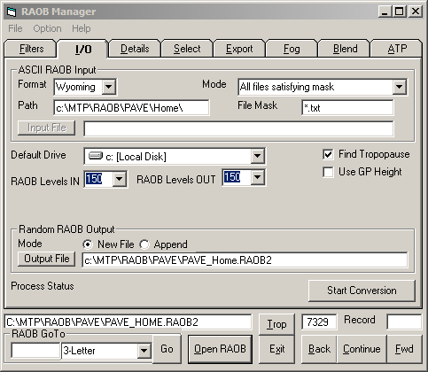
Figure 4. RAOBman I/O tab.
After a campaign, binary RAOB files should be created for all the
individual soundings in each of the mission sub-folders. To do this,
select the RAOBman I/O tab and on the ASCII RAOB Input frame specify the
relevant information as shown in Figure
4. Generally, the only change needed is to add the sub-folder
name to the Path text box (Home\ in this example). Then in the Random RAOB Output frame, specify
the name of the binary output file (PAVE_Home.RAOB2
in this example), and whether you are appending to an existing file. In
this example, we are selecting the New
File option. Finally, click the Start Conversion button to do the
conversion from many ASCII .txt files to a single binary RAOB2 file.

Figure 6. RAOBman Filters tab.
Once binary RAOB files have been created for each sub-folder, a single
file should be created which contains all of the available soundings.
Let's call the file that will contain all of the soundings PAVE_All.RAOB2, and let's suppose
that we want to add the soundings in the PAVE_Home.RAOB2 file to it. The
first step is to set some filters to avoid copying files that will not
be useable. As shown in Figure 6,
we have turned on a filter on the RAOBman
Filters tab in the Valid RAOB Data Needed frame to
only include soundings that reached at least 20 km pressure altitude.

Figure 7. RAOBman Select tab.
Next we select the RAOBman Select tab shown in Figure 7, and click the Search button. As shown 7,071 of
the 7,329 soundings in the PAVE_Home.RAOB2
file reached >20 km.
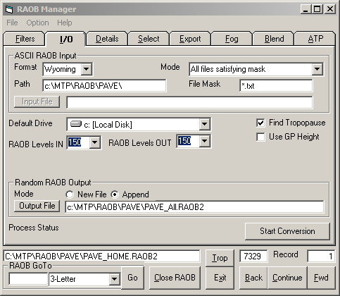
Figure 8. RAOBman I/O tab.
To add these files to the PAVE_All.RAOB2
file, we select the RAOBman I/O tab and in the Random RAOB Output frame change the
output filename to PAVE_All.RAOB2
and select the Append option
as shown in Figure 8. Then we
go back to the Select tab (Figure 7) and click the Write button to append the selected
PAVE_Home.RAOB2 soundings to
the PAVE_All.RAOB2 file.
An alternative method which avoids appending files together is to
simply copy all the soundings to a single sub-folder (e.g. \All\) and use ROABman to convert them all to
binary RAOB file (e.g., PAVE_All.RAOB2)
using the same steps as outlined above. That is, don't bother creating
binary RAOB files such RAOB_Home.RAOB2.
Previous Step | Next Step | Index |
RAOB File Data Structure
Type
RAOBrecord2
WMOnumber As
Long
'WMO Number of launch site
WMO4l
As String *
4
'ICAO name
RAOBedit As
Integer
'
DandT
As
Date
'Date and Time in IEEE 64-bit format
Nlevr
As
Integer
'Number of ROAB levels
dTMRI
As Single
'MRI parameter
Ztrop
As Single
'Tropopause pressure altitude (km)
Ttrop
As Single
'Tropopause temperature (K)
Ltrop
As Integer
ZtropE
As Single
'Editted Tropopause pressure altitude (km)
TtropE
As Single
'Editted Tropopause temperature (K)
LtropE
As Integer
ijkl
As
Integer
'BLG index for RAOB interpolation (not used)
OATraob As
Single
'OAT at flight altitude for WCT
OATraobPP As
Single
'PP variation of OAT for 4 WCT RAOBs
WMOlatitude As
Single 'WMO
Latitude of launch site
WMOlongitude As Single
'WMO Longitude of launch site
WMOaltitude As Integer
'WMO Geopotential Height of launch site
zMRI1
As
Single
'ALT km at dTMRI
zMRI2
As
Single
'ALT km at dTMRI
Ztrop2
As
Single
'Second Tropopause pressure altitude (km)
Ttrop2
As
Single
'Second Tropopause temperature (K)
Ltrop2
As Integer
IntRhoV As
Single
'Integrated water vapor
Tcoldest As
Single
'Coldest temperature in RAOB (K)
Zcoldest As
Single
'Altitude of coldest temperature (km)
nRAOBlevels As Integer
'Number of RAOB levels
SpareInt As Integer
Spare(1 To 3) As Single
GZr2(1
To 153) As Integer 'Geometric Altitude [m]
PZr2(1
To 153) As Integer 'Pressure
altitude [0.1mb]
TZr2(1
To 153) As Integer 'Temperatures [10 mK]
RZr2(1
To 153) As Integer 'Relative Humidity
[0.01%]
LZr2(1
To 3) As Integer 'Editted
level number
End Type