17 April 1995
Vortex NOAA Aircraft Mission #4
Flight ID:
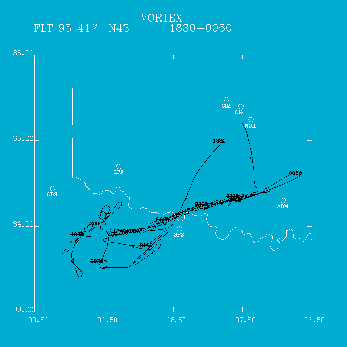
Flight Track:
Click image for full resolution.
Flight Crew:
Chief Scientist: Watson/Ziegler         Flight Director:  Damiano
Doppler Radar:   Shepherd               Pilots:           Tenneson/Kennedy
Cloud Physics:   ---                    Data Technician:  Pradas
Radiometer:      Fedor                  Systems Engineer: Lynch/McNamara
Observer:        Irisov
Observer:        Hutchinson


Takeoff Time: 1817 UTC                  Landing Time: 0053 UTC
Official Mission Duration: 7.0 hrs
Mission Breakdown VORTEX: 7.0 hrs       ARM: 0.0 hrs
Number of Data Tapes Used:  Radar: 6    Cloud Physics: 1        Video: 3


Data Systems Log
Radar Data System Log   Time On(UTC)    Time Off(UTC)   Comments
Tape #1                 1913                            Start LF&TA
                                        2130            Radar down
Tape #2                 2140
                                        2206            Radar down
Tape #3                 2216                            No Spectral Width
                                        2344            Radar Problems
Tape #4                 2350
                                        0054


Cloud Physics Log       Time On(UTC)    Time Off(UTC)   Comments
                        1830            0030


ETL Radiometer Log      Time On (UTC)   Time Off (UTC)  Comments
                        1805            0002            Poor data til 2000
UTC
Reason: Due to precipitation before and after takeoff, signal level on one
channel was erratic due to precipitation.
Summary:
The predeparture plan was that strong dynamics would produce
severe convection in the slot between clouds and the dryline. The ground
intercept teams departed OUN at 1510 UTC for Wichita Falls, TX. The P-3
departed OKC at 1817 UTC climbing, in clouds, to FL100 and heading for
Wichita Falls.
We reconnoitered weak developing high base convection near
and south of Guthrie, TX. We setup on cells near Seymour, TX, executing
6 Doppler legs as the cells weakened considerably. We then drifted
westward for a somewhat stronger-looking cell. Our first Doppler leg
began at 2120 UTC. Intermittent radar problems plagued data collection
until 2209 UTC. Thinking that the problem was data overload, we eliminated
recording of spectral width, and in desperation, eliminated the second
tape copy. Radar appeared to work well after that. BWER and tops to
18 km were observed at 2150 UTC. At 2256 UTC, a tornado was reported by
the ground teams near Temple, OK. By 2312 UTC, the mesocyclone seemed
to occlude in on itself. The mesocyclone appeared to detached itself
from the parent cloud while a new notch began to form.
Tornado sightings and warnings of tornadoes continued past 0045 UTC
when another tornado was reported near Davis, OK. The P-3 documented
the evolution of this supercell from 2120 UTC until we broke for OKC at
0031 UTC when it became apparent that OKC was going to have thunderstorms.
Twenty-four Doppler legs were completed on this supercell.
The NCAR Electra, after doing frontal and dryline work, joined us on
the tornadic storm around 2330 UTC. Both aircraft landed back at OKC
just ahead of the squal line. It appears that a great dataset was collected
Due to the evolution of the mesocyclone southward, many of the legs
appeared to be 20-25 km from the main portion of the storm. Seven hours
of flight time were consumed.
Irv Watson
Return to Case Study Page