Flight ID:
- 940529I
Click image for full resolution.
Chief Scientist: Watson/Ziegler         Flight Director:  Damiano
Doppler Radar:   Shepherd/Sanger        Pilots:           Ticknor/Kennedy
Cloud Physics:   Jacobs                 Data Technician:  Pradas
Observer:        Wakimoto               Systems Engineer: Lynch
Observer:        Bluestein
Media:

Takeoff Time: 1833 UTC                  Landing Time: 0205 UTC
Official Mission Duration: 7.7 hrs
Number of Data Tapes Used:  Radar: 2    Cloud Physics: 1        Video: 3
                                                We now have 3 video cameras

Data Systems Log
Tape #1                 1947                            Start LF/TA
                                        2105            Radar down -
                                                        switching
                                                        boards
Tape #2                 2121                            Start radar REC
                                        0128            Shutdown REC

Cloud Physics Log       Time On(UTC)    Time Off(UTC)   Comments
                        2220            0136            One array on the
                                                        precip
                                                        probe gets stuck on
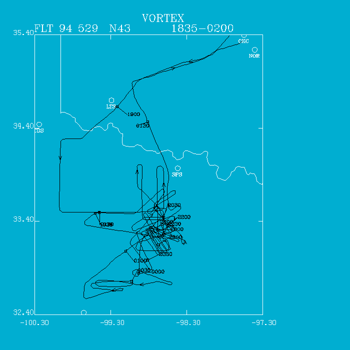
NOAA 43 departed Will Rogers at 1833 UTC, climbing to 10,000'. We performed the descent sounding west of Quanah to 1000' AGL. At that point we proceeded southward on our box pattern in northwest flow, eventually encountering a convergent boundary with windshift, 3 degree dewpoint rise, and cumulus (rope) line west of Archer City. We broke off the box pattern and did a north-south leg at 1000' AGL along 99 W where the meso vortex was located on Frederick (FDR) WSR-88D radar.
At 2012 UTC, we climbed to 5000' to provide the ground teams repeater service and proceeded southward to developing TCUs along the boundary. We did some east-west tracks on the highly sheared towers showing little development, mostly being pinched off at mid-levels. Very weak returns were noted in the TCU field.
The radar failed between 2102 and 2121 UTC. Of course, the cells started blossoming during this period. We proceeded to near Olney, TX where the ground crews were deploying. We initially setup NE-SW legs behind the echo at 2145 UTC. This was not optimum. At 2157 UTC, we decided to do Doppler legs SE-NW parallel to the anvil remaining at 10,000'. After a few rough rides through flanking TCU, we descended to 2500' AGL and continued the convective patterns. At 2301 UTC, a wall cloud was visible and a very nice hook with a possible second hook on LF. At 2310 UTC, a moderate tornado was visible extending from the wall cloud approximately 5 miles northwest of our position as we continued NW. On the next pass westward, the tornado was much thinner approaching the rope stage. All in all, we did some 20 passes on this storm, 14 before wall cloud stage and 6 during and after tornadic stage.
The ground teams broke off this system and started heading to another storm to the southwest. We continued for a time on the old storm getting beat up by turbulence. We executed a few passes on the storm to the southwest breaking off from convective mode at 0049 UTC. NOAA 43 continued to provide repeater service for the ground teams as they had difficulty exiting the storm area due to heavy precipitation. We arrived at OKC at 0205 UTC.
This will be one of the most spectacular cases ever collected from an aircraft. A quick check of the radar data reveals an unbelievable bounded, weak-echo region (BWER), may be even seeing evidence of the tornadic circulation at mid-levels in the echo vault.
Irv Watson