Flight ID:
- 940610I
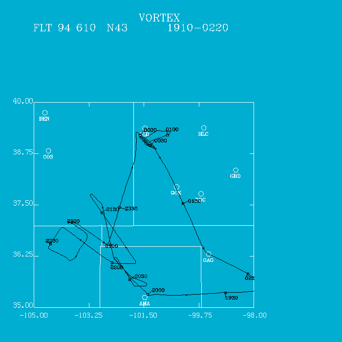
Flight Track:
Click image for full resolution.
Chief Scientist: Watson/Ziegler Flight Director: Damiano Doppler Radar: Shepherd/Million Pilots: Ticknor/Kennedy Cloud Physics: Pradas Data Technician: Jacobs Observer: Bluestein Systems Engineer: Lynch Observer: Emlaw (NWS) Takeoff Time: 1907 UTC Landing Time: 0216 UTC Official Mission Duration: 7.4 hrs Number of Data Tapes Used: Radar: 1 Cloud Physics: 0 Video: 3Data Systems Log
Radar Data System Log Time On(UTC) Time Off(UTC) Comments Tape #1 2024 Start LF 2201 Start TA 0143 Stop record Cloud Physics Log Time On(UTC) Time Off(UTC) Comments 1922 0158 Recycled tape No data
We then proceeded NNW to sample the boundary layer into SE Colorado at 500' AGL, which probably would fill in with convection along an imaginary line between weather in western Kansas and convection in southern Colorado and NE New Mexico. Little was noted as we followed the terrain. Winds, however, backed from the south to SE. We made contact again with the FC at 2134 UTC. The FC suggested we examined the mountain convection NW of Dalhart, TX. Much of the convection was dissipating, looked miserable, both on radar, and visually. At 2308 UTC we informed the FC of what we found; he cancelled operations and released the aircraft. He would, later, regroup the ground teams when a supercell developed near Amarillo and tracked southward.
Upon being released, we headed north to Goodland, KS where there had been severe weather reports. Our first Doppler pass was initiated on a weak supercell at 2357 UTC, visually noting a small wall cloud and very little precipitation. We made 9 passes on the supercell and documented its demise. At 0049 UTC, the cell disconnected itself from the low-level cumulus and the mid/upper level cloud and anvil. Very interesting dissapation! We departed the area at 0047 UTC, arriving back at Will Rogers at 0216 UTC consuming 7.4 hours. This flight ended VORTEX aircraft operations for 1994, a successful beginning, even during a poor tornado year.
Irv Watson