Flight ID:
- 940608I
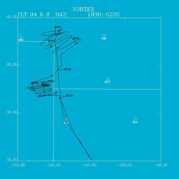
Flight Track:
Click image for full resolution.
Chief Scientist: Watson/Ziegler Flight Director: Damiano Doppler Radar: Shepherd/Atkins Pilots: Ticknor/Kennedy Cloud Physics: Pradas Data Technician: Jacobs Observer: Bluestein Systems Engineer: Lynch Observer: Jones (NWS) Observer: Hutchinsen Takeoff Time: 1932 UTC Landing Time: 0228 UTC Official Mission Duration: 7.2 hrs Number of Data Tapes Used: Radar: 2 Cloud Physics: 0 Video: 3Data Systems Log
Radar Data System Log Time On(UTC) Time Off(UTC) Comments Tape #1 2116 Start LF 2131 Start TA 2328 Radar down Tape #2 2333 Start REC again 0132 Stop Record Cloud Physics Log Time On(UTC) Time Off(UTC) Comments No clouds - No data
We departed Will Rogers at 1932 UTC. The FC had already departed about the day when we made initial contact. He suggested we fly at 10,000' northwest to the Oklahoma panhandle to check the extent of warm temperatures at 700 mb. On our track, temperatures decreased slightly from 15 to 13 C. At Englewood, KS (extreme southern Kansas), we performed a descent sounding to 500' AGL which showed a severe cap (6 C inversion) at 830 mb. We then contacted the FC (2027 UTC), who had already cancelled ground operations and, at that time, released us to seek out severe convection elsewhere.
Based upon the FC and EFF's suggestions, we headed northbound to convective development already occurring in western Nebraska. NOAA 43 arrived in the vicinity of the convection one hour and 15 minutes later (2142 UTC). We would work a linear system near Sidney, NE for approximately an hour before deciding it would not tornado. Several cells looked good in the line containing bounded weak echo regions. Howie Bluestein reported a "gustnado" on the outflow boundary at 2215 UTC.
At 2306 UTC, we headed southbound for an isolated cell about 50 nm southwest of the line we were working. At 2306 UTC, we started our first pass westbound. At 2321 UTC, we observed a funnel cloud (tornado) extending out of a small narrow wall cloud. Upon reversing track, the tornado had dissapated and the wall cloud had become wrapped in rain. We executed some 14 passes on the supercell as it evolved, first, by weakening somewhat, then, by the time we had to depart, the cloud had developed a nice horseshoe-shape appearance. Tom Shepherd, on radar, did at least 4 passes using all fores and all afts technique. On the last few passes, we observed striations at midlevels of the cloud indicative of a rotating mesocyclone.
Irv Watson