Flight ID:
- 940607I
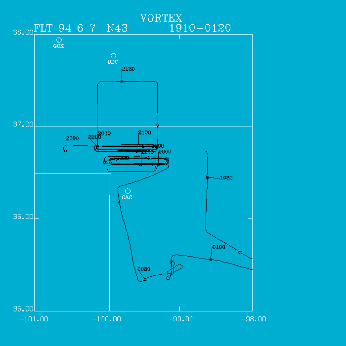
Flight Track:
Click image for full resolution.
Chief Scientist: Watson/Ziegler Flight Director: Damiano Doppler Radar: Shepherd/MacGorman Pilots: Ticknor/Kennedy Cloud Physics: Jacobs Data Technician: Pradas Observer: Bluestein Systems Engineer: Lynch Observer: Wood, Churchill Takeoff Time: 1903 UTC Landing Time: 0118 UTC Official Mission Duration: 6.4 hrs Number of Data Tapes Used: Radar: 0 Cloud Physics: 0 Video: 3Data Systems Log
Radar Data System Log Time On(UTC) Time Off(UTC) Comments No data recorded
NOAA 43 departed OKC at 1903 UTC, climbing to 8,000' heading for Alva, OK. We executed a descent sounding near Alva showing a temperature of 16 C at 700 mb, a very high temperature for convective development.
At 1934 UTC, we headed westbound at 500' encountering the dryline about 12 nm east of Laverne, OK. The dryline was diffuse with gradual changes extending 30 nm west. A few small cumulus extended both north and south of our track. We then executed stepped tranverses (500' AGL, 1500' AGL, and 5500' MSL) performing 2 sets. At 2102 UTC, we started a 45' (lat- long) box at 500' AGL. On our northbound leg, winds became ESE, while on our southbound leg, winds were more southerly, indicative of divergence.
At 2214 UTC, we relocated south to 36 30' N along with the ground teams, and executed 3 complete sets of stepped traverses. The dryline had become more tight and sharp with very abrupt changes in temperature, dewpoint, and winds. Temperatures at 500' AGL reached 39 C. The cumulus field, which peaked at 2200 UTC, was waning. Therefore, at 0000 UTC, we broke the pattern and headed for Foss, OK to survey for damage on a supercell storm which occurred the day before, 6 June. The pilots made contact with the Clinton-Sherman airport tower. The tower operator directed the aircraft to the damage area near I-40 and north of I-40. No extensive damage was seen.
Irv Watson