VOCALS Working Group Report
A major goal of the Seventh Annual Meeting of the VAMOS program (VPM7) in Guayaquil, Ecuador was to develop the scientific and implementation plans for the VAMOS Ocean Cloud Atmosphere and Land Studies (VOCALS). The membership of the VOCALS working group at VPM7 included Chris Bretherton, Bob Weller, Oscar Pizarro, Rodrigo Nuñez, José Rutllant, René Garreaud, Efrain Rodríguez, Roberto Mechoso, Chris Fairall, Pilar Cornejo, Rodney Martínez, Gus Emmanuel, and Leila Zambrano. At this meeting, chairmanship of VOCALS passed from Chris Bretherton to Bob Weller.
- Interactions with weather systems (including deep convection) and with climate variations over South America on seasonal to interannual (S/I) time scales,
- Feedback with the underlying and ocean,
- Response to and impact on variability in remote locations. These activities include diagnostic and modeling studies, sustained observations, and pilot and enhanced observational programs, including a multi-investigator, cooperative process study.
The scientific
rationale for VOCALS was developed at
past VAMOS meetings, with major progress made at VPM6 in Miami, USA. Among the scientific issues to be
addressed are:
On what time and space scales does continental heating/mechanical forcing impact boundary layer cloud/radiative forcing?
How sensitive is the overall tropical circulation and ENSO to variations of Eastern Pacific cloud topped boundary layer properties and why?
What are dominant S/I feedbacks among stratocumulus clouds, surface winds, upwelling, coastal currents and SST in the Eastern Pacific?
Does natural and anthropogenic aerosol variability significantly modulate the startocumulus? Further offshore, the cloud drop radii are larger; Why?
Because there is more aerosol near the coast? Pollution? Ocean productivity, DMS? Salt/wind?
How does this feedback on mean stratocumulus albedo? PBL structure?
What processes control SST (sea surface temperature) and upper ocean heat content and structure over the domain?
What is the connectivity of the ocean to variability in remote regions?
How sensitive is the stratus deck to local ocean variability?
What controls SST in the Eastern Tropical Pacific?
What are the roles of Ekman transport, eddy heat transport to the west, local air-sea interaction and other processes?
What drives vertical mixing at the buoy sites and with what success do ocean GCMs replicate the heat balance and the mixing processes?
What is the horizontal distribution of nutrients in the upper ocean and is it related to offshore transport mechanisms?
What is the space/time nature of eddy heat transport offshore?
What does the vertical ocean (and atmosphere) cross-section look like along a latitude line?
Is regional ocean modeling of 1500 km nearest South American coast realistic; can it replicate the observed cross section?
Is regional atmospheric modeling along the coast realistic?
With what success do regional atmospheric models replicate the coastal wind jet and its relation with coastal upwelling and clouds?
How coupled are the oceanic and atmospheric boundary layers on S/I time scales?
Does local forcing drive the seasonal cycle of SST? Are there continental influences on long timescales?
Are there cloud feedbacks on ENSO evolution?
To address these issue,
observations now underway include the WHOI surface mooring at 20°S,
85°W, the
SHOA DART buoy at 20°S, 75°W, meteorological observations at
San Felix Island,
cruises to service the WHOI buoy, cooperative cruises by Chile, Peru,
Ecuador,
and Colombia, coastal subsurface moorings deployed by the University of
Concepcion, and the annual cruise to service the WHOI and DART buoys
(each
October or November). The WHOI
buoy was deployed in October 2000 and was a focal point for EPIC2001
fieldwork
done in October 2001 as a pilot for VOCALS. The
DART buoy was deployed in November 2003. Standard
surface observations are taken
at San Felix by the Chilean Navy; the University of Chile is working to
add
additional instrumentation in advance of October 2007, with the goal of
obtaining data at least one year in advance. Satellite
data sets from a domain centered on the region are
being archived and analyzed. Also,
global and mesoscale model evaluation and improvement are being
undertaken
using multiscale data sets.
The primary focus for the group's efforts at VPM7 was to advance the plans for implementation of work to address these issues and hypotheses that have been developed around them. In particular, the intent at VPM7 was to develop a timeline leading up to and including an international process study and to identify the key components of the work that has to be accomplished.
The VOCALS Working Group identified October of 2007 as the time period best for the process study; climatologically, October is the time of the large extent of the stratus cloud deck.
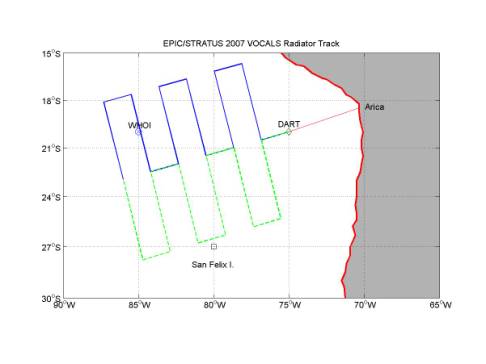
Planning at VPM7 for the October 2007 process study led to development of the following framework: Use of a research aircraft (NCAR C-130) flying long, basically east-west legs from northern Chile with cloud radar, sampling for aerosols, cloud microphysics, turbulent fluxes, with dropsondes and passive microwave; using both constant level and profiling flight legs. Use of aerosondes flying from northern Chile or from San Felix Island for boundary layer profiling and radiation and aerosols if possible. A large oceanographic research vessel (NOAA Ship Ronald H. Brown) to work west from the coast out past the WHOI buoy in a large scale radiator pattern extending down to San Felix to do oceanography (towed SeaSoar and underway ADCP, physical and biological sampling), deploy Argo profiling floats and surface drifters, measure air-sea exchanges, and carry cloud radar, C-band radar, lidar, radiosondes, and aerosol sampling instrumentation. Use of a coastal oceanographic ship to address the meteorology, physical and biological oceanography and coupling of the ocean, atmosphere and land in the near-shore region. Use of the late 2007 CPPS (Comision Permanente del Pacifico Sur, a multinational cooperative effort to study the South Pacific) cruise to do additional sampling of coastal oceanography and meteorology. On station at that time would be the WHOI buoy at 20°S, 85°W, the SHOA DART mooring at 20°S, 75°W, and the Univ. of Concepcion coastal moorings. Use would be made of sampling done on the annual transect to Easter Island made by SHOA. Instrumentation on San Felix would be augmented, as would instrumentation at coastal meteorological sampling sites. Satellite remote sensing would be used for large-scale coverage of the ocean surface, of sea level height, of the atmosphere, and of the clouds. A month long intensive field phase is needed, with the month of October chosen as the month when stratus coverage is most extensive. Figure 1 provides a map of the location and a schematic of the shipboard sampling.
In preparation for the October 2007 VOCALS process experiment, enhanced sampling is recommended using the SHOA DART buoy (add meteorological sensors), using San Felix (resolve power reliability and add enhanced instrumentation, including wind profiler, radiation, cloud/precipitation radar, microwave liquid water profiler, and aerosol sampler), from the October or November cruises (using the NOAA ETL surface flux and remote sensing instrumentation) to service the WHOI and DART buoys, by adding additional ARGO floats and surface drifters to the region, and by sampling from CPPS and Peruvian and Chilean cruises in the region.
Up and to 2007 efforts will continue in diagnostic, sensitivity, parameterization studies of SE Pacific stratocumulus and their variability using data collected to date, satellite and model products, and the enhancements to the observations noted above. Particular foci would be use of these data for testing of physical parameterizations used in global and regional models, improving understanding of the observed feedbacks between aerosol, drizzle, mesoscale cellular structure, and the diurnal cycle in this region. Ocean diagnostic and modeling studies would begin using data now being collected and the historical data to refine sampling strategies aimed at quantifying the relatives roles of air-sea interaction, Ekman transport, eddy transport, geostrophic transport and other processes in setting SST under the stratus clouds. Model studies would also examine the influence of remote forcing (for example, at the equator where a Kelvin wave could be excited that propagates east to create a costal trapped wave that moves south into the region of interest) on the oceanographic and meteorological variability of the region. Global atmospheric and coupled models would complement the regional oceanographic and meteorological modeling.
VOCALS data management efforts will spin up to collect, archive, and share remote sensing data, model data, and the field data. Links will be maintained with the US CLIVAR cloud-climate Climate Process Team (CPT) that will be working to transition better understanding and parameterizations into coupled model development, as well as with the GEWEX Cloud System Study (GCSS) Boundary Layer Cloud working group, which organizes international comparisons of large-eddy simulation and atmospheric single-column models. Dialog has started with international CLIVAR, including VAMOS, to link with and solicit interest from the modeling working groups.
The preparations for October 2007 would lead up to a 'dry-run' of the VOCALS experiment, in which the plans for ship and aircraft tracks would be tested and refined using model and satellite fields together with data from the 2003-2006 WHOI buoy servicing cruise. The timeline for enhancements to San Felix, the DART buoy, and coastal installations are set by the desire to have these enhancements operational for this 'dry-run' and to ensure data collection in 2006 as well as in 2007 to cope with and observe possible interannual variability.